Difference between revisions of "2013-08-12 37 -122"
From Geohashing
imported>Thomcat ([live picture] Bus route map - San Jose airport [http://www.openstreetmap.org/?lat=37.36395106&lon=-121.92263907&zoom=16&layers=B000FTF @37.3640,-121.9226]) |
imported>Thomcat (add plans) |
||
| Line 25: | Line 25: | ||
== Plans == | == Plans == | ||
| − | + | Headed there via #57 then #32 VTA bus. ETA 5:30-ish | |
== Expedition == | == Expedition == | ||
Revision as of 23:22, 12 August 2013
| Mon 12 Aug 2013 in 37,-122: 37.3639954, -122.0104473 geohashing.info google osm bing/os kml crox |
Location
Participants
Plans
Headed there via #57 then #32 VTA bus. ETA 5:30-ish
Expedition
Tracklog
Photos
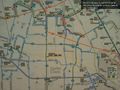
Bus route map - San Jose airport @37.3640,-121.9226

Achievements