Difference between revisions of "2013-08-31 42 2"
From Geohashing
imported>Dunaril ([live picture] [http://www.openstreetmap.org/?lat=42.92290000&lon=2.26328000&zoom=16&layers=B000FTF @42.9229,2.2633]) |
imported>Dunaril ([http://www.openstreetmap.org/?lat=42.92290000&lon=2.26327000&zoom=16&layers=B000FTF @42.9229,2.2633]) |
||
| Line 36: | Line 36: | ||
Image:2013-08-31_42_2_14-50-22-916.jpg | [http://www.openstreetmap.org/?lat=42.92290000&lon=2.26328000&zoom=16&layers=B000FTF @42.9229,2.2633] | Image:2013-08-31_42_2_14-50-22-916.jpg | [http://www.openstreetmap.org/?lat=42.92290000&lon=2.26328000&zoom=16&layers=B000FTF @42.9229,2.2633] | ||
| + | |||
| + | Image:2013-08-31_42_2_15-05-43-925.jpg | [http://www.openstreetmap.org/?lat=42.92290000&lon=2.26327000&zoom=16&layers=B000FTF @42.9229,2.2633] | ||
</gallery> | </gallery> | ||
Revision as of 13:05, 31 August 2013
| Sat 31 Aug 2013 in 42,2: 42.9194046, 2.2660901 geohashing.info google osm bing/os kml crox |
Location
In Rennes-le-Château, not far from the road, on some rocky place surrounded by a small stream (reachability unknown at this point).
Participants
Dunaril and family.
Plans
We are on our way from vacation, road tripping today from Collioure to Gaillac. I have successfully bended our itinerary to pass by this geohash, and potentially another one just North of here. We'll see if the point is really reachable.
Expedition
Tracklog
Photos
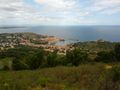
The place we left this morning. Collioure is so beautiful. On our way now. @42.5148,3.0880


Achievements