Difference between revisions of "2013-09-13 40 -74"
From Geohashing
imported>Jevanyn ([live] Closest approach is here, inside the margin of error. Long time no geohash, nice to have a chance to do this again :-)) |
imported>Jevanyn ([live picture] The view east (I'll fix the orientation when I get to a real computer) [http://www.openstreetmap.org/?lat=40.47334059&lon=-74.87820780&zoom=16&layers=B000FTF @40.4733,-74.8782]) |
||
| Line 42: | Line 42: | ||
Image:2013-09-13_40_-74_13-52-18-686.jpg | Closest intersection, plus a silly face [http://www.openstreetmap.org/?lat=40.47320050&lon=-74.87837229&zoom=16&layers=B000FTF @40.4732,-74.8784] | Image:2013-09-13_40_-74_13-52-18-686.jpg | Closest intersection, plus a silly face [http://www.openstreetmap.org/?lat=40.47320050&lon=-74.87837229&zoom=16&layers=B000FTF @40.4732,-74.8784] | ||
| + | |||
| + | Image:2013-09-13_40_-74_14-00-10-929.jpg | The view east (I'll fix the orientation when I get to a real computer) [http://www.openstreetmap.org/?lat=40.47334059&lon=-74.87820780&zoom=16&layers=B000FTF @40.4733,-74.8782] | ||
</gallery> | </gallery> | ||
Revision as of 18:00, 13 September 2013
| Fri 13 Sep 2013 in 40,-74: 40.4731319, -74.8772739 geohashing.info google osm bing/os kml crox |
Location
Participants
Plans
Expedition
- Closest approach is here, inside the margin of error. Long time no geohash, nice to have a chance to do this again :-) -- Jevanyn (talk) @40.4732,-74.8773 13:55, 13 September 2013 (EDT)
Tracklog
Photos

Closest intersection, plus a silly face @40.4732,-74.8784
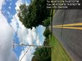
The view east (I'll fix the orientation when I get to a real computer) @40.4733,-74.8782


Achievements