Difference between revisions of "2014-02-06 54 -2"
From Geohashing
imported>Angel |
imported>Angel |
||
| Line 63: | Line 63: | ||
[[Category:Expeditions]] | [[Category:Expeditions]] | ||
| + | -- and one or more of -- | ||
[[Category:Expeditions with photos]] | [[Category:Expeditions with photos]] | ||
| + | <!-- if you reached your coords: | ||
| + | [[Category:Coordinates reached]] | ||
| + | |||
| + | |||
| + | --><!-- or if you failed :( | ||
[[Category:Coordinates not reached]] | [[Category:Coordinates not reached]] | ||
| + | -- and a reason -- | ||
| + | When there is a natural obstacle between you and the target: | ||
| + | [[Category:Not reached - Mother Nature]] | ||
| + | |||
| + | When there is a man-made obstacle between you and the target: | ||
| + | [[Category:Not reached - No public access]] | ||
| + | |||
| + | When you failed get your GPS, car, bike or such to work: | ||
| + | [[Category:Not reached - Technology]] | ||
| + | |||
| + | When you went to an alternate location instead of the actual geohash: | ||
| + | [[Category:Not reached - Did not attempt]] | ||
| + | |||
| + | (Don't forget to delete this final close comment marker) --> | ||
Revision as of 23:50, 6 February 2014
| Thu 6 Feb 2014 in 54,-2: 54.0709214, -2.6714825 geohashing.info google osm bing/os kml crox |
Location
In a field somewhere off a road past Halton.
Participants
Plans
Walk up the cyclepath, see if I can get there, return to Lancaster via Quernmore.
Expedition
Went part way; blood sugar went low; panicked and aborted with 4.5 miles to go.
Tracklog
Photos
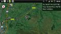
Pretty sure this'll end up 'private property', but must be worth a try @54.0538,-2.7910
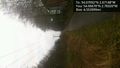
Aborted due to low blood sugar :( @54.0667,-2.7832


Achievements
-- and one or more of --