Difference between revisions of "2014-05-21 49 10"
From Geohashing
imported>Schnatterfleck (The hashpoint as located by my GPS - surprisingly nice area! Schnatterfleck [http://www.openstreetmap.org/?lat=49.36880000&lon=10.82900000&zoom=16&layers=B000FTF @49.3688,10.8290]) |
imported>Schnatterfleck (Aeaeah... Routing app?... You're kidding, right...?? [http://www.openstreetmap.org/?lat=49.41280000&lon=10.90250000&zoom=16&layers=B000FTF @49.4128,10.9025]) |
||
| Line 40: | Line 40: | ||
Image:2014-05-21_49_10_Schnatterfleck_-1.jpg | The hashpoint as located by my GPS - surprisingly nice area! Schnatterfleck [http://www.openstreetmap.org/?lat=49.36880000&lon=10.82900000&zoom=16&layers=B000FTF @49.3688,10.8290] | Image:2014-05-21_49_10_Schnatterfleck_-1.jpg | The hashpoint as located by my GPS - surprisingly nice area! Schnatterfleck [http://www.openstreetmap.org/?lat=49.36880000&lon=10.82900000&zoom=16&layers=B000FTF @49.3688,10.8290] | ||
| + | |||
| + | Image:2014-05-21_49_10_Schnatterfleck_1400683035587.jpg | Aeaeah... Routing app?... You're kidding, right...?? [http://www.openstreetmap.org/?lat=49.41280000&lon=10.90250000&zoom=16&layers=B000FTF @49.4128,10.9025] | ||
</gallery> | </gallery> | ||
Revision as of 03:13, 22 May 2014
| Wed 21 May 2014 in 49,10: 49.3687540, 10.8289638 geohashing.info google osm bing/os kml crox |
Location
Participants
Plans
Expedition
Tracklog
Photos
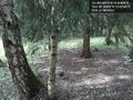
The hashpoint as located by my GPS - surprisingly nice area! Schnatterfleck @49.3688,10.8290
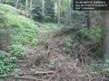
Aeaeah... Routing app?... You're kidding, right...?? @49.4128,10.9025


Achievements