Difference between revisions of "2014-07-13 47 11"
From Geohashing
imported>LeslieHapablap ([live] Summit geohash!) |
imported>LeslieHapablap |
||
| Line 17: | Line 17: | ||
<!-- edit as necessary --> | <!-- edit as necessary --> | ||
__NOTOC__ | __NOTOC__ | ||
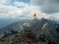
| + | [[Image:2014-07-13 47 11 rosskopf summit.jpg|thumb|left|200px]] | ||
== Location == | == Location == | ||
<!-- where you've surveyed the hash to be --> | <!-- where you've surveyed the hash to be --> | ||
| − | + | The Roßkopf summit (30 m from the peak). | |
== Participants == | == Participants == | ||
<!-- who attended: If you link to your wiki user name in this section, your expedition will be picked up by the various statistics generated for geohashing. You may use three tildes ~ as a shortcut to automatically insert the user signature of the account you are editing with. | <!-- who attended: If you link to your wiki user name in this section, your expedition will be picked up by the various statistics generated for geohashing. You may use three tildes ~ as a shortcut to automatically insert the user signature of the account you are editing with. | ||
| Line 26: | Line 27: | ||
== Plans == | == Plans == | ||
<!-- what were the original plans --> | <!-- what were the original plans --> | ||
| − | + | We had several points in the mountains already, but that a hashpoint lies directly on a summit has not happened before. If the weather permits, we will go for it. | |
== Expedition == | == Expedition == | ||
<!-- how it all turned out. your narrative goes here. --> | <!-- how it all turned out. your narrative goes here. --> | ||
Revision as of 15:04, 11 July 2014
| Sun 13 Jul 2014 in 47,11: 47.2236532, 11.5907277 geohashing.info google osm bing/os kml crox |
Location
The Roßkopf summit (30 m from the peak).
Participants
Plans
We had several points in the mountains already, but that a hashpoint lies directly on a summit has not happened before. If the weather permits, we will go for it.
Expedition
- Summit geohash! -- LeslieHapablap (talk) 10:59, 11 July 2014 (EDT)
Tracklog
Photos
Achievements
