Difference between revisions of "2014-10-10 51 9"
From Geohashing
imported>GeorgDerReisende (create page) |
imported>GeorgDerReisende (expedition report for Helsa-Eschenstruth) |
||
| Line 1: | Line 1: | ||
| − | |||
| − | |||
| − | |||
| − | |||
| − | |||
| − | |||
| − | |||
| − | |||
| − | |||
| − | |||
{{meetup graticule | {{meetup graticule | ||
| lat=51 | | lat=51 | ||
| Line 18: | Line 8: | ||
__NOTOC__ | __NOTOC__ | ||
== Location == | == Location == | ||
| − | + | ||
| + | The hash lay on a meadow near Helsa-Eschenstruth. | ||
== Participants == | == Participants == | ||
| − | + | ||
| − | + | [[User:GeorgDerReisende|GeorgDerReisende]] | |
== Plans == | == Plans == | ||
| − | + | ||
| + | I wanted to hitchhike to Eschenstruth and to walk around it. | ||
== Expedition == | == Expedition == | ||
| − | |||
| − | + | I left home at 11 o'clock, started to hitchhike at 11:55 and got a lift after ten minutes. Then I walked through Eschenstruth and to the hash. I found the hash on a meadow. But it was fenced in with electric wire. So I couldn't walk to the hash! | |
| − | |||
== Photos == | == Photos == | ||
| Line 38: | Line 28: | ||
--> | --> | ||
<gallery perrow="5"> | <gallery perrow="5"> | ||
| + | Image: 2014-10-10 51 9 GeorgDerReisende 7941.jpg | 40 meters to hash, but two fences hindered me to go | ||
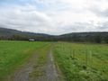
| + | Image: 2014-10-10 51 9 GeorgDerReisende 7945.jpg | view to the west | ||
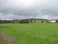
| + | Image: 2014-10-10 51 9 GeorgDerReisende 7944.jpg | view to the north | ||
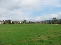
| + | Image: 2014-10-10 51 9 GeorgDerReisende 7947.jpg | view to the east | ||
| + | Image: 2014-10-10 51 9 GeorgDerReisende 7946.jpg | view to the south | ||
| + | Image: 2014-10-10 51 9 GeorgDerReisende 7949.jpg | the unlucky geohasher | ||
| + | Image: 2014-10-10 51 9 GeorgDerReisende 7926.jpg | the main street of Eschenstruth | ||
| + | Image: 2014-10-10 51 9 GeorgDerReisende 7980.jpg | view to Eschenstruth | ||
</gallery> | </gallery> | ||
| Line 45: | Line 43: | ||
| − | + | [[Category:Expeditions]] | |
| − | |||
| − | [[Category: | ||
| − | |||
| − | |||
| − | |||
| − | |||
| − | |||
| − | |||
| − | |||
| − | |||
| − | |||
| − | |||
[[Category:Expeditions with photos]] | [[Category:Expeditions with photos]] | ||
| − | |||
| − | |||
| − | |||
| − | |||
| − | |||
| − | |||
| + | [[Category:Coordinates not reached]] | ||
| − | |||
| − | |||
| − | |||
| − | |||
| − | |||
| − | |||
| − | |||
[[Category:Not reached - No public access]] | [[Category:Not reached - No public access]] | ||
| − | |||
| − | |||
| − | |||
| − | |||
| − | |||
| − | |||
| − | |||
| − | |||
Revision as of 14:59, 10 October 2014
| Fri 10 Oct 2014 in 51,9: 51.2238467, 9.6590847 geohashing.info google osm bing/os kml crox |
Location
The hash lay on a meadow near Helsa-Eschenstruth.
Participants
Plans
I wanted to hitchhike to Eschenstruth and to walk around it.
Expedition
I left home at 11 o'clock, started to hitchhike at 11:55 and got a lift after ten minutes. Then I walked through Eschenstruth and to the hash. I found the hash on a meadow. But it was fenced in with electric wire. So I couldn't walk to the hash!
Photos
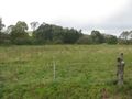
40 meters to hash, but two fences hindered me to go
view to the west
view to the north
view to the east
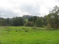
view to the south
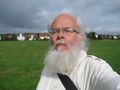
the unlucky geohasher
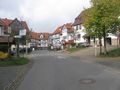
the main street of Eschenstruth
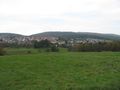
view to Eschenstruth


