Difference between revisions of "2015-01-11 45 -75"
From Geohashing
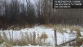
imported>Jlam ([live picture] Other side of Moodie drive from the geohash. These kinds of desolate landscapes just faacinate me. [http://www.openstreetmap.org/?lat=45.21950000&lon=-75.77330000&zoom=16&layers=B000FTF @45.2195,-75.7733]) |
imported>Jlam (→Location) |
||
| Line 19: | Line 19: | ||
== Location == | == Location == | ||
<!-- where you've surveyed the hash to be --> | <!-- where you've surveyed the hash to be --> | ||
| + | |||
| + | Moodie Dr, possibly on Lafarge property. | ||
== Participants == | == Participants == | ||
Revision as of 23:12, 11 January 2015
| Sun 11 Jan 2015 in 45,-75: 45.2192347, -75.7727021 geohashing.info google osm bing/os kml crox |
Location
Moodie Dr, possibly on Lafarge property.
Participants
Plans
Expedition
Tracklog
Photos
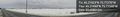
About as close as I'll get to the geohash without winter boots or jumping that fence. @45.2189,-75.7733
Other side of Moodie drive from the geohash. These kinds of desolate landscapes just faacinate me. @45.2195,-75.7733

Achievements