Difference between revisions of "2015-02-22 48 8"
imported>DODO (→Photos) |
imported>DODO (→Photos) |
||
| Line 49: | Line 49: | ||
--> | --> | ||
<gallery perrow="5"> | <gallery perrow="5"> | ||
| − | Image:2015-02-22_48_8- | + | Image:2015-02-22_48_8-2.jpg|the french border in Scheibenhard |
| − | Image:2015-02-22_48_8-1.jpg| | + | Image:2015-02-22_48_8-1.jpg|where I bought some cakes at the border |
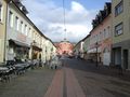
| − | Image:2015-02-22_48_8-3.jpg| | + | Image:2015-02-22_48_8-3.jpg|the city of Niederroeden |
| − | Image:2015-02-22_48_8-4.jpg| | + | Image:2015-02-22_48_8-4.jpg|I left my bull near the road ... |
| − | Image:2015-02-22_48_8-5.jpg| | + | Image:2015-02-22_48_8-5.jpg|... 135 m from the hash... |
| − | Image:2015-02-22_48_8-6.jpg| | + | Image:2015-02-22_48_8-6.jpg|...and walked into the copse ... |
| − | Image:2015-02-22_48_8-7.jpg|a | + | Image:2015-02-22_48_8-7.jpg|...that soon cleared to a fern-area... |
| − | Image:2015-02-22_48_8-8.jpg| | + | Image:2015-02-22_48_8-8.jpg|... where I reached the hash. |
| − | Image:2015-02-22_48_8-9.jpg| | + | Image:2015-02-22_48_8-9.jpg|view to the west |
| − | Image:2015-02-22_48_8-10.jpg| | + | Image:2015-02-22_48_8-10.jpg|to the north |
| − | Image:2015-02-22_48_8-11.jpg| | + | Image:2015-02-22_48_8-11.jpg|to the east |
| − | Image:2015-02-22_48_8-12.jpg| | + | Image:2015-02-22_48_8-12.jpg|and to the hasher |
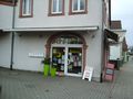
| − | Image:2015-02-22_48_8-13.jpg| | + | Image:2015-02-22_48_8-13.jpg|the cakes I bought in Scheibenhard |
| − | Image:2015-02-22_48_8-14.jpg| | + | Image:2015-02-22_48_8-14.jpg|the chalk-mark I left |
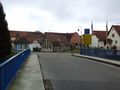
| − | Image:2015-02-22_48_8-15.jpg| | + | Image:2015-02-22_48_8-15.jpg|and the german border again (the river rhine is the border, and so Germany begins in the middle of this bridge) |
| − | Image:2015-02-22_48_8-16.jpg| | + | Image:2015-02-22_48_8-16.jpg|church... |
| − | Image:2015-02-22_48_8-17.jpg| | + | Image:2015-02-22_48_8-17.jpg|...castle... |
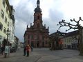
| − | Image:2015-02-22_48_8-18.jpg| | + | Image:2015-02-22_48_8-18.jpg|...and townhall of Rastatt |
| − | Image:2015-02-22_48_8-19.jpg| | + | Image:2015-02-22_48_8-19.jpg|dog at the next table |
| − | Image:2015-02-22_48_8-20.jpg| | + | Image:2015-02-22_48_8-20.jpg|ice, coffee and bull (outside) |
</gallery> | </gallery> | ||
Revision as of 19:39, 22 February 2015
| Sun 22 Feb 2015 in 48,8: 48.8986501, 8.0406906 geohashing.info google osm bing/os kml crox |
Location
In the forest (or a fern-filed) south of Niederroedern.
Participants
Plans
I have some time today and the nearest geohash is in the french part of the southern graticule. That might bring some shiny ribbons.
Expedition
I saddled the bull in the morning and headed southwards. After 50 KM I reached the french border. After this the landscape got a little bit more wavy and much nicer (but maybe thats just because it's foreign). Half an hour later I reached Niederroeden and took some pictures. And a kilometer further I reached a roundabout where I tethered the bull and had just 135 m to go to the hash.
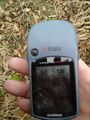
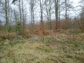
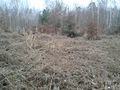
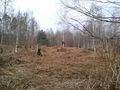
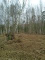
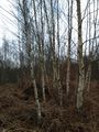
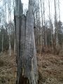
It looks like dense copse, but after a short fight with some raptors I reached a big area covered with dry fern. It would have been hardly possible to cross the area in summer when the fern is high and dense and its probably very hard to walk through when it is wet, but neither of both took place and so I could walk very good on the dry fern. 50 m further I reached the hash. I took some pictures, left a mark, ate some doughnuts and walked back to my bull.
Four KM later I reached the border again and crossed it in the german direction this time. Another half an hour and I reached Rastatt. I still had some time before my train departs, and I filled this time with some coffee and some ice-cream. I reached the station in Rastatt at 15:15 and had plenty of time before the train departs at 15:34. One change in Karlsruhe and a good hour later I reached my home again.
Tracklog
Photos
the french border in Scheibenhard
where I bought some cakes at the border
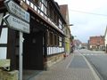
the city of Niederroeden
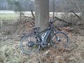
I left my bull near the road ...
... 135 m from the hash...
...and walked into the copse ...
...that soon cleared to a fern-area...
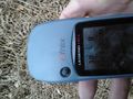
... where I reached the hash.
view to the west
to the north
to the east
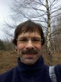
and to the hasher
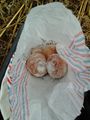
the cakes I bought in Scheibenhard
the chalk-mark I left
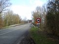
and the german border again (the river rhine is the border, and so Germany begins in the middle of this bridge)
church...
...castle...
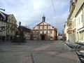
...and townhall of Rastatt
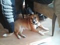
dog at the next table
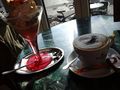
ice, coffee and bull (outside)


Achievements