Difference between revisions of "2015-08-22 -12 130"
imported>Felix Dance (Felix, Pinto and Lucy at the Mandorah hash. [http://www.openstreetmap.org/?lat=-12.70595128&lon=130.62252566&zoom=16&layers=B000FTF @-12.7060,130.6225]) |
imported>Felix Dance (Added text) |
||
| Line 14: | Line 14: | ||
| date=2015-08-22 | | date=2015-08-22 | ||
}} | }} | ||
| − | |||
| − | |||
| − | |||
== Location == | == Location == | ||
| − | + | Next to the Cox Peninsula Road west of Darwin and its harbour. | |
== Participants == | == Participants == | ||
| − | + | *[[User:Felix Dance|Felix Dance]] | |
| − | + | *Lucy | |
| + | *Pinto | ||
| + | |||
| + | == Expedition == | ||
| + | I discovered this geohash at work. My quest to finally get to Darwin's South East graticule had been thwarted, and it looked like Sunday's location could have been feasible, but, it being a significant drive, and on the same day as a croc dissection Lucy was organising at Darwin Uni, I decided it wasn't worth it. This was my consolation prize. | ||
| − | + | Meeting Lucy in Palmerston after work, I was amazed to find that she was receptive of the idea of visiting the day's hash - in fact, she suggested it herself. So, with her enormous Newfoundland in the back (star of [[2015-08-16 -12 130|previous]] [[2015-07-24 -12 130|geohashes]]), we deviated from our path to the park and instead bee-lined for the hash - bypassing my own worksite along the way. | |
| − | |||
| − | + | Stopping only for an iced coffee and diet coke, we zoomed along and soon were parking and alighting from the vehicle. After a bit of random wandering trying to get the GPS to show as at the point, and getting bitten by wildly coloured red ants, we were there. Photo taken and back in the car, we detoured from the route home to have dinner at Crab Claw Beach, south of Crocodile Island (which is where I think the photo below thinks it was taken - it was actually at the hash point, however, and we do have photos to prove it). | |
| − | |||
== Tracklog == | == Tracklog == | ||
<!-- if your GPS device keeps a log, you may post a link here --> | <!-- if your GPS device keeps a log, you may post a link here --> | ||
| + | No tracklog, but [https://goo.gl/maps/MWv6y this] is a rough trace of our drive. | ||
== Photos == | == Photos == | ||
Revision as of 05:11, 26 August 2015
| Sat 22 Aug 2015 in -12,130: -12.6552329, 130.7231957 geohashing.info google osm bing/os kml crox |
Location
Next to the Cox Peninsula Road west of Darwin and its harbour.
Participants
- Felix Dance
- Lucy
- Pinto
Expedition
I discovered this geohash at work. My quest to finally get to Darwin's South East graticule had been thwarted, and it looked like Sunday's location could have been feasible, but, it being a significant drive, and on the same day as a croc dissection Lucy was organising at Darwin Uni, I decided it wasn't worth it. This was my consolation prize.
Meeting Lucy in Palmerston after work, I was amazed to find that she was receptive of the idea of visiting the day's hash - in fact, she suggested it herself. So, with her enormous Newfoundland in the back (star of previous geohashes), we deviated from our path to the park and instead bee-lined for the hash - bypassing my own worksite along the way.
Stopping only for an iced coffee and diet coke, we zoomed along and soon were parking and alighting from the vehicle. After a bit of random wandering trying to get the GPS to show as at the point, and getting bitten by wildly coloured red ants, we were there. Photo taken and back in the car, we detoured from the route home to have dinner at Crab Claw Beach, south of Crocodile Island (which is where I think the photo below thinks it was taken - it was actually at the hash point, however, and we do have photos to prove it).
Tracklog
No tracklog, but this is a rough trace of our drive.
Photos
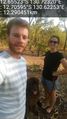
Felix, Pinto and Lucy at the Mandorah hash. @-12.7060,130.6225

Achievements