Difference between revisions of "2016-04-02 47 -122"
From Geohashing
imported>Thomcat ([live picture]Meeting point for tomorrow's 4:00 expedition [http://www.openstreetmap.org/?lat=47.56069490&lon=-122.36015020&zoom=16&layers=B000FTF @47.5607,-122.3602]) |
imported>Thomcat (Details) |
||
| Line 19: | Line 19: | ||
== Location == | == Location == | ||
| − | + | The woods in Pigeon Point, not far off a trail. | |
== Participants == | == Participants == | ||
<!-- who attended: If you link to your wiki user name in this section, your expedition will be picked up by the various statistics generated for geohashing. You may use three tildes ~ as a shortcut to automatically insert the user signature of the account you are editing with. | <!-- who attended: If you link to your wiki user name in this section, your expedition will be picked up by the various statistics generated for geohashing. You may use three tildes ~ as a shortcut to automatically insert the user signature of the account you are editing with. | ||
--> | --> | ||
| + | * Thomcat | ||
| + | * Boomzilla | ||
== Plans == | == Plans == | ||
<!-- what were the original plans --> | <!-- what were the original plans --> | ||
| + | Happen to be working close by this afternoon, so I checked it out. Very reachable! Thomcat will be there at 4 p.m. | ||
== Expedition == | == Expedition == | ||
Revision as of 21:40, 1 April 2016
| Sat 2 Apr 2016 in 47,-122: 47.5602894, -122.3576946 geohashing.info google osm bing/os kml crox |
Location
The woods in Pigeon Point, not far off a trail.
Participants
- Thomcat
- Boomzilla
Plans
Happen to be working close by this afternoon, so I checked it out. Very reachable! Thomcat will be there at 4 p.m.
Expedition
Tracklog
Photos
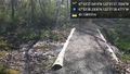
South of here @47.5606,-122.3579
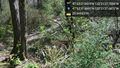
... and down. @47.5605,-122.3577
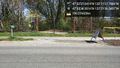
Meeting point for tomorrow's 4:00 expedition @47.5607,-122.3602


Achievements