Difference between revisions of "2016-08-27 47 -122"
From Geohashing
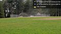
imported>Thomcat ([live picture]View of the sound [http://www.openstreetmap.org/?lat=47.53095860&lon=-122.39865490&zoom=16&layers=B000FTF @47.5310,-122.3987]) |
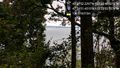
imported>Thomcat ([live picture]Beach trail [http://www.openstreetmap.org/?lat=47.52973740&lon=-122.39899650&zoom=16&layers=B000FTF @47.5297,-122.3990]) |
||
| Line 51: | Line 51: | ||
Image:2016-08-27_47_-122_thomcat_1472308499148.jpg|View of the sound [http://www.openstreetmap.org/?lat=47.53095860&lon=-122.39865490&zoom=16&layers=B000FTF @47.5310,-122.3987] | Image:2016-08-27_47_-122_thomcat_1472308499148.jpg|View of the sound [http://www.openstreetmap.org/?lat=47.53095860&lon=-122.39865490&zoom=16&layers=B000FTF @47.5310,-122.3987] | ||
| + | |||
| + | Image:2016-08-27_47_-122_thomcat_1472308618921.jpg|Beach trail [http://www.openstreetmap.org/?lat=47.52973740&lon=-122.39899650&zoom=16&layers=B000FTF @47.5297,-122.3990] | ||
</gallery> | </gallery> | ||
Revision as of 14:36, 27 August 2016
| Sat 27 Aug 2016 in 47,-122: 47.5311749, -122.3968392 geohashing.info google osm bing/os kml crox |
Location
Participants
Plans
Expedition
Tracklog
Photos

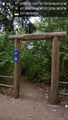
Almost there @47.5311,-122.3933
Dragging the diamond @47.5328,-122.3946
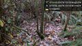
Lots of brush & webs @47.5311,-122.3968

Geohasher @47.5311,-122.3969

Lots of trees too @47.5312,-122.3969
View of the sound @47.5310,-122.3987
Beach trail @47.5297,-122.3990


Achievements