Difference between revisions of "2017-02-10 52 -1"
imported>Pbro m (Typo) |
imported>Pbro (Thumbnail) |
||
| Line 1: | Line 1: | ||
| − | |||
| − | [[Image:{{{image| | + | [[Image:{{{image|2017-02-10_52_-1_sunset.jpg}}}|thumb|left]] |
| − | |||
| − | |||
| − | |||
| − | |||
| − | |||
{{meetup graticule | {{meetup graticule | ||
| lat=52 | | lat=52 | ||
| Line 14: | Line 8: | ||
| date=2017-02-10 | | date=2017-02-10 | ||
}} | }} | ||
| + | [[User:Pbro|Pbro]] walked around this hash point without reaching it. | ||
<!-- edit as necessary --> | <!-- edit as necessary --> | ||
| Line 30: | Line 25: | ||
== Expedition == | == Expedition == | ||
| − | At 4pm, I hopped on my bicycle, rode it to Crackley Lane and locked it on a conveniently placed bridge railing. From there I took a Public Footpath north. The footpath crosses the field the hash is on, and I passed it in 174 m distance. At the next intersection I turned south again. The public right of way then however leaves the path along the field (the path is closed by a gate). This time I approached the hash to a distance of 77 m. At that time I resigned myself to not reaching this hash and returned to my bicycle. | + | At 4pm, I hopped on my bicycle, rode it to Crackley Lane (3.1 km) and locked it on a conveniently placed bridge railing. From there I took a Public Footpath north. The footpath crosses the field the hash is on, and I passed it in 174 m distance. At the next intersection I turned south again. The public right of way then however leaves the path along the field (the path is closed by a gate). This time I approached the hash to a distance of 77 m. At that time I resigned myself to not reaching this hash and returned to my bicycle (2 km walk). |
Weather: Rays of sun fighting through the clouds, but at the end a flutter of snowflakes. Temperature just above freezing. | Weather: Rays of sun fighting through the clouds, but at the end a flutter of snowflakes. Temperature just above freezing. | ||
Revision as of 00:16, 11 February 2017

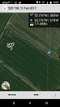
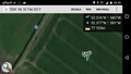
| Fri 10 Feb 2017 in 52,-1: 52.3762865, -1.5801558 geohashing.info google osm bing/os kml crox |
Pbro walked around this hash point without reaching it.
Location
In a field belonging to Hurst Farm off Crackley Lane, Kenilworth, Warwickshire, CV8 2JW, UK.
The hash turned out to be in a field of grain, with 5 cm long shoots, so actually reaching it was out of question. A public right of way footpath crosses that field, and the right of way seems to have been maintained by spraying it with a plant killer.
Participants
Plans
Less than 2km away from work -- even though I had low hopes as the hashpoint is on private farm land, I hopped on my bike in the afternoon.
Expedition
At 4pm, I hopped on my bicycle, rode it to Crackley Lane (3.1 km) and locked it on a conveniently placed bridge railing. From there I took a Public Footpath north. The footpath crosses the field the hash is on, and I passed it in 174 m distance. At the next intersection I turned south again. The public right of way then however leaves the path along the field (the path is closed by a gate). This time I approached the hash to a distance of 77 m. At that time I resigned myself to not reaching this hash and returned to my bicycle (2 km walk).
Weather: Rays of sun fighting through the clouds, but at the end a flutter of snowflakes. Temperature just above freezing.
Photos
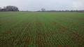
Hashpoint is on the other side of that grain field.
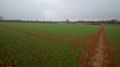
But we cannot leave the public footpath.
So we stay 170 m away.
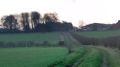
Closed gate prohibits access.
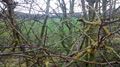
Now the hash is on the far side of the hedge.
Only 70 m away!
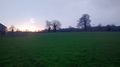
Last rays of the sun fighting snowflakes.


Achievements
Pbro earned the No trespassing consolation prize
|