Difference between revisions of "2017-02-26 48 11"
From Geohashing
imported>Micsnare (→Participants) |
imported>B2c (→Tracklog) |
||
| Line 41: | Line 41: | ||
*Meh -- [[User:B2c|B2c]] ([[User talk:B2c|talk]]) [http://www.openstreetmap.org/?lat=48.17158030&lon=11.56240020&zoom=16&layers=B000FTF @48.1716,11.5624] 15:59, 26 February 2017 (GMT+01:00) | *Meh -- [[User:B2c|B2c]] ([[User talk:B2c|talk]]) [http://www.openstreetmap.org/?lat=48.17158030&lon=11.56240020&zoom=16&layers=B000FTF @48.1716,11.5624] 15:59, 26 February 2017 (GMT+01:00) | ||
== Tracklog == | == Tracklog == | ||
| − | + | [[File:2017-02-26-48_11-tracklog.png]] | |
== Photos == | == Photos == | ||
Revision as of 15:26, 27 February 2017
| Sun 26 Feb 2017 in 48,11: 48.1715527, 11.5623797 geohashing.info google osm bing/os kml crox |
Location
The geohash was located in a housing complex in Munich, Germany.
Participants
Plans
Expedition
- Yay, we're there ;) -- Micsnare (talk) @48.1716,11.5623 15:59, 26 February 2017 (GMT+01:00)
- Woohoo -- B2c (talk) @48.1716,11.5624 15:58, 26 February 2017 (GMT+01:00)
- Meh -- B2c (talk) @48.1716,11.5624 15:59, 26 February 2017 (GMT+01:00)
Tracklog

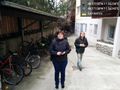
Photos

Woohoo Surprise Meetup!! @48.1716,11.5624
Woohoo Meetup @48.1716,11.5624

One more time!!! @48.1716,11.5624


Achievements