Difference between revisions of "2018-02-27 49 11"
From Geohashing
imported>Thomcat ([live picture]Geohasher) |
imported>Thomcat ([live] Less than 13m?) |
||
| Line 24: | Line 24: | ||
*Left the Messe - time to geohash! -- [[User:Thomcat|Thomcat]] ([[User talk:Thomcat|talk]]) [http://www.openstreetmap.org/?lat=49.44596770&lon=11.08257660&zoom=16&layers=B000FTF @49.4460,11.0826] 17:17, 27 February 2018 (GMT+01:00) | *Left the Messe - time to geohash! -- [[User:Thomcat|Thomcat]] ([[User talk:Thomcat|talk]]) [http://www.openstreetmap.org/?lat=49.44596770&lon=11.08257660&zoom=16&layers=B000FTF @49.4460,11.0826] 17:17, 27 February 2018 (GMT+01:00) | ||
| + | |||
| + | *Less than 13m? -- [[User:Thomcat|Thomcat]] ([[User talk:Thomcat|talk]]) [http://www.openstreetmap.org/?lat=49.75632270&lon=11.05378500&zoom=16&layers=B000FTF @49.7563,11.0538] 19:04, 27 February 2018 (GMT+01:00) | ||
== Tracklog == | == Tracklog == | ||
<!-- if your GPS device keeps a log, you may post a link here --> | <!-- if your GPS device keeps a log, you may post a link here --> | ||
Revision as of 18:05, 27 February 2018
| Tue 27 Feb 2018 in Nürnberg: 49.7561222, 11.0540555 geohashing.info google osm bing/os kml crox |
Location
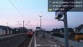
Along the Nürnberg-Bamberg S1 tracks, between Forchheim and Eggolsheim.
Participants
Plans
Afternoon S1 to Eggolsheim, then S1 back to Nürnberg.
Using my cell (and battery) all day at the trade show, so picturage will be limited. Must follow the maxim - If In Doubt, Go GeoHashing! (IIDGGH!)
Expedition
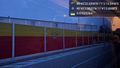
- Left the Messe - time to geohash! -- Thomcat (talk) @49.4460,11.0826 17:17, 27 February 2018 (GMT+01:00)
- Less than 13m? -- Thomcat (talk) @49.7563,11.0538 19:04, 27 February 2018 (GMT+01:00)
Tracklog
Photos
Forchheim @49.7173,11.0702

Geohasher @49.7561,11.0542
Eggolsheim @49.7751,11.0367
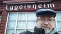
Geohasher


Achievements