Difference between revisions of "2018-10-16 32 34"
From Geohashing
imported>Dubdub ([live] After one bus ride, we are half a kilometer away) |
imported>Dubdub ([live picture]We with the bus) |
||
| Line 47: | Line 47: | ||
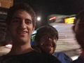
Image:2018-10-16_32_34_Dubdub_1539710780669.jpg|First stop: A bus station in Ramat Hasharon [http://www.openstreetmap.org/?lat=32.14683540&lon=34.83906950&zoom=16&layers=B000FTF @32.1468,34.8391] | Image:2018-10-16_32_34_Dubdub_1539710780669.jpg|First stop: A bus station in Ramat Hasharon [http://www.openstreetmap.org/?lat=32.14683540&lon=34.83906950&zoom=16&layers=B000FTF @32.1468,34.8391] | ||
| + | |||
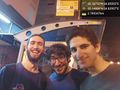
| + | Image:2018-10-16_32_34_Dubdub_1539711690001.jpg|We with the bus | ||
</gallery> | </gallery> | ||
Revision as of 17:41, 16 October 2018
| Tue 16 Oct 2018 in 32,34: 32.1675043, 34.8559224 geohashing.info google osm bing/os kml crox |
Location
The location where in Neve Amal, near Herzeliya, a major Israeli city.
Participants
Jordy (talk), Dubdub and a friend
Plans
Expedition
- After one bus ride, we are half a kilometer away -- Dubdub (talk) 20:41, 16 October 2018 (GMT+03:00)
Tracklog
Photos
First stop: A bus station in Ramat Hasharon @32.1468,34.8391
We with the bus


Achievements