Difference between revisions of "2008-06-07 41 -96"
From Geohashing
imported>AtomicLlama |
|||
| Line 1: | Line 1: | ||
| + | {{meetup graticule | ||
| + | | map=<map lat="41" lon="-96" date="2008-06-07" /> | ||
| + | | lat=41 | ||
| + | | lon=-96 | ||
| + | | date=2008-06-07 | ||
| + | }} | ||
| + | |||
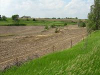
The point was in a fenced field just off of County Road P35 northwest of Fort Calhoun. | The point was in a fenced field just off of County Road P35 northwest of Fort Calhoun. | ||
Revision as of 14:01, 10 June 2008
| Sat 7 Jun 2008 in 41,-96: 41.5017842, -96.1143708 geohashing.info google osm bing/os kml crox |
The point was in a fenced field just off of County Road P35 northwest of Fort Calhoun.
Expeditions
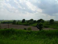
- Matt and Kate arrived right at 4:00pm. Had to drive by and turn around to find a place to park the car. The closest I could get to the point was about 30 feet away, outside the fence. Took a couple of pictures and left within 5 minutes because I had to park closer to the road than I would have liked. The scenery on the drive to the point was excellent for eastern Nebraska.

