Difference between revisions of "User:J0e"
From Geohashing
imported>J0e |
imported>J0e |
||
| Line 12: | Line 12: | ||
Nearest town: Sigerslevvester <br> | Nearest town: Sigerslevvester <br> | ||
Surroundings: Cultivated field - inaccessible <br> | Surroundings: Cultivated field - inaccessible <br> | ||
| − | Navigation: Google maps, no GPS <br> | + | Navigation: Google maps, visual, no GPS <br> |
It was a beautiful day, so I went there despite inaccessible surroundings and no GPS. <br> | It was a beautiful day, so I went there despite inaccessible surroundings and no GPS. <br> | ||
Revision as of 22:02, 29 June 2008
Location: Copenhagen graticule (55 12)
Main reason for going geohashing: Photography
I prefer solo expeditions, since I'm too busy doing my own thing.
It's not that I'm not friendly - just preoccupied.
First expedition
20th June 2008
Target: 55.881283082188, 12.0866543637585
Nearest town: Sigerslevvester
Surroundings: Cultivated field - inaccessible
Navigation: Google maps, visual, no GPS
It was a beautiful day, so I went there despite inaccessible surroundings and no GPS.
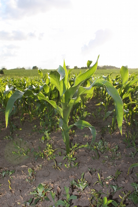
I was rewarded with some pictures of a maize field (wow!) :-)
Borrowed an old better-than-nothing Garmin the next day.
