Difference between revisions of "2020-05-07 39 -77"
From Geohashing
([live] This location happened to be at the strawberry Hill nature preserve.) |
([live picture]The view from the spot itself [https://openstreetmap.org/?lat=39.80184470&lon=-77.41293230&zoom=16&layers=B000FTF @39.8018,-77.4129]) |
||
| Line 48: | Line 48: | ||
Image:2020-05-07_39_-77_OfficeLinebacker_1588893976816.jpg|Tree grown around tire [https://openstreetmap.org/?lat=39.80183680&lon=-77.41290960&zoom=16&layers=B000FTF @39.8018,-77.4129] | Image:2020-05-07_39_-77_OfficeLinebacker_1588893976816.jpg|Tree grown around tire [https://openstreetmap.org/?lat=39.80183680&lon=-77.41290960&zoom=16&layers=B000FTF @39.8018,-77.4129] | ||
| + | |||
| + | Image:2020-05-07_39_-77_OfficeLinebacker_1588894096551.jpg|The view from the spot itself [https://openstreetmap.org/?lat=39.80184470&lon=-77.41293230&zoom=16&layers=B000FTF @39.8018,-77.4129] | ||
</gallery> | </gallery> | ||
Revision as of 23:28, 7 May 2020
| Thu 7 May 2020 in 39,-77: 39.8018104, -77.4128954 geohashing.info google osm bing/os kml crox |
Location
Participants
Plans
Expedition
- I think I shall attempt this one today. -- OfficeLinebacker (talk) 13:53, 7 May 2020 (EDT)
- This location happened to be at the strawberry Hill nature preserve. -- OfficeLinebacker (talk) @39.8018,-77.4129 19:27, 7 May 2020 (EDT)
Tracklog
Photos
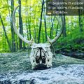
Skull @39.7693,-77.3934
Made it! @39.8018,-77.4129
The crossing @39.8018,-77.4129
A tank @39.8018,-77.4129
Tree grown around tire @39.8018,-77.4129
The view from the spot itself @39.8018,-77.4129
Achievements


