|
|
| Line 21: |
Line 21: |
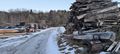
| | File:2021-01-24 07.50.27.jpg | looking south an the sawmill | | File:2021-01-24 07.50.27.jpg | looking south an the sawmill |
| | </gallery> | | </gallery> |
| − |
| |
| − | == Achievements ==
| |
| − | {{#vardefine:ribbonwidth|800px}}
| |
| − |
| |
| − | {{Hash collision
| |
| − |
| |
| − | | latitude = 48
| |
| − | | longitude = 11
| |
| − | | date = 2020-12-19
| |
| − | | name = Clearlucid9
| |
| − | | id = GC3KXNG
| |
| − | | link = https://coord.info/GC3KXNG
| |
| − | | distance = 20m
| |
| − |
| |
| − | }}
| |
| − | {{bicycle geohash
| |
| − |
| |
| − | | latitude = 48
| |
| − | | longitude = 11
| |
| − | | date = date 2020-12-19
| |
| − | | name = Clearlucid9
| |
| − | | distance = 3km
| |
| − | | bothways = true
| |
| − |
| |
| − | }}
| |
| − | {{Frozen Geohash
| |
| − |
| |
| − | | latitude = 48
| |
| − | | longitude = 11
| |
| − | | date = date 2020-12-19
| |
| − | | temperature = -1°C
| |
| − | | name = learlucid9
| |
| − |
| |
| − | }}
| |
| − | <!-- =============== USEFUL CATEGORIES FOLLOW ================
| |
| − | Delete the next line ONLY if you have chosen the appropriate categories below. If you are unsure, don't worry. People will read your report and help you with the classification. -->
| |
| − | [[Category:New report]]
| |
| − |
| |
| − | <!-- ==REQUEST FOR TWITTER BOT== Please leave either the New report or the Expedition planning category in as long as you work on it. This helps the twitter bot a lot with announcing the right outcome at the right moment. -->
| |
| − |
| |
| − | <!-- Potential categories. Please include all the ones appropriate to your expedition -->
| |
| − | <!-- If this is a planning page:
| |
| − | [[Category:Expedition planning]]
| |
| − | -->
| |
| − |
| |
| − | <!-- If all those plans are never acted upon, change [[Category:Expedition planning]] to [[Category:Not reached - Did not attempt]]. -->
| |
| − |
| |
| − | <!-- An actual expedition:
| |
| − | [[Category:Expeditions]]
| |
| − | -- and one or more of --
| |
| − | [[Category:Expeditions with photos]]
| |
| − | [[Category:Expeditions with videos]]
| |
| − | [[Category:Expedition without GPS]]
| |
| − | -->
| |
| − |
| |
| − | <!-- if you reached your coords:
| |
| − | [[Category:Coordinates reached]]
| |
| − |
| |
| − |
| |
| − | --><!-- or if you failed :(
| |
| − | [[Category:Coordinates not reached]]
| |
| − | -- and a reason --
| |
| − | When there is a natural obstacle between you and the target:
| |
| − | [[Category:Not reached - Mother Nature]]
| |
| − |
| |
| − | When there is a man-made obstacle between you and the target:
| |
| − | [[Category:Not reached - No public access]]
| |
| − |
| |
| − | When you failed get your GPS, car, bike or such to work:
| |
| − | [[Category:Not reached - Technology]]
| |
| − |
| |
| − | When you went to an alternate location instead of the actual geohash:
| |
| − | [[Category:Not reached - Attended alternate location]]
| |
| − |
| |
| − | (Don't forget to delete this final close comment marker) -->
| |
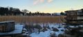
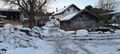
Location
Next to an old sawmill in Moosach/Falkenberg, south of Munich
Participants
Clearlucid9 (talk)
Expedition
"Should I do this hash?" I had been asking myself yesterday and as the answer was "yes" I set the alarm clock early in the morning so that I would be back for the family breakfast. I had looked up the satellite photos beforehand and wasn't 100% sure if I would be able to get there as there seemed to be a house in the way, but the road either side of the house kind of indicated that there would be a passage route. After I drove through and looked to park the car I then realised that I was almost parking "on the spot". I still got out of my car to take the pictures, but was back in the warm driver seat in no time, which was a good thing as the wind was blowing freezing cold! After that I went for a Geocache in the area and then to a bakery to bring bread for the family ;-)
Photos
me, standing on the hashpoint
looking south an the sawmill