Difference between revisions of "2021-03-31 50 7"
Gefrierbrand (talk | contribs) (→Achievements) |
Gefrierbrand (talk | contribs) |
||
| Line 1: | Line 1: | ||
| − | + | {{meetup graticule | |
| − | |||
| − | |||
| − | |||
| − | |||
| − | |||
| − | |||
| − | |||
| − | |||
| lat=50 | | lat=50 | ||
| lon=7 | | lon=7 | ||
| date=2021-03-31 | | date=2021-03-31 | ||
| − | }} | + | }} |
__NOTOC__ | __NOTOC__ | ||
== Location == | == Location == | ||
| Line 22: | Line 14: | ||
== Plans == | == Plans == | ||
| − | + | Walk there, celebrate, return. | |
== Expedition == | == Expedition == | ||
| − | + | Well, this one was surprisingly hard to reach. | |
| + | |||
| + | The hash was very near Gefierbrands flat (almost exactly 1 km) and located only a few meters from a nice small path on what looked like steep, but easily reachable terrain on the map. It would have been possible to approach the hash from the hillside, but we desided against going downhill into unknown terrain and chose a path through a nice little valley instead, even though this ment we had to cross a small stream at some point. | ||
| + | |||
| + | To our delight, there was a little wodden bridge pretty much exactly where we had intended to traverse the water. However, our luck stopped there for a while. We had to climb the hillside. The remaining straigt line distance was ony a few dozen meters, but besides being steep, the terrain was also rugged, covered in brambles and other very thorny shrubbery and slippery (as you can see in one of the pictures). Moreover the GPS reception was initially bad and we had to rummage arround for quite a bit until luck returned and Santu managed to find the exact location. | ||
| + | |||
| + | Pedro somehow managed to navigate through all this and also had a much easier time returning back down than his human counterparts. We were covered with painfull stitches everywhere, but the dog escaped unscathed. | ||
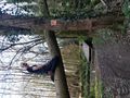
| + | Since one fallen down tree was particulary inviting, both Santu and gefrierbrand had to climb on it on their way back. | ||
== Photos == | == Photos == | ||
Revision as of 08:52, 2 April 2021
| Wed 31 Mar 2021 in 50,7: 50.2978890, 7.4449001 geohashing.info google osm bing/os kml crox |
Location
On a thorn-covered, steep hill near Kobern-Gondorf
Participants
- Gefrierbrand
- Santu
- Pedro the dog
Plans
Walk there, celebrate, return.
Expedition
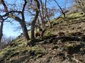
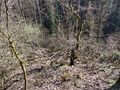
Well, this one was surprisingly hard to reach.
The hash was very near Gefierbrands flat (almost exactly 1 km) and located only a few meters from a nice small path on what looked like steep, but easily reachable terrain on the map. It would have been possible to approach the hash from the hillside, but we desided against going downhill into unknown terrain and chose a path through a nice little valley instead, even though this ment we had to cross a small stream at some point.
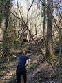
To our delight, there was a little wodden bridge pretty much exactly where we had intended to traverse the water. However, our luck stopped there for a while. We had to climb the hillside. The remaining straigt line distance was ony a few dozen meters, but besides being steep, the terrain was also rugged, covered in brambles and other very thorny shrubbery and slippery (as you can see in one of the pictures). Moreover the GPS reception was initially bad and we had to rummage arround for quite a bit until luck returned and Santu managed to find the exact location.
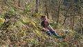
Pedro somehow managed to navigate through all this and also had a much easier time returning back down than his human counterparts. We were covered with painfull stitches everywhere, but the dog escaped unscathed.
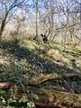
Since one fallen down tree was particulary inviting, both Santu and gefrierbrand had to climb on it on their way back.
Photos
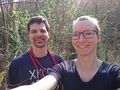
StupidGrinTM
Pedro being brave in difficult terrain
Santu climbing ahead
thorny brambles everywhere
thicket downhill.
oops
Santu climbing a tree

Santu in front of Gefrierbrand on the same tree

coordinates reached


Achievements
Gefrierband & Santu earned the Land geohash achievement
|
Gefrierband & Santu earned the Walk geohash Achievement
|
