Difference between revisions of "2021-07-04 39 -76"
From Geohashing
([live picture]Weigh station nearby. A cop came and asked me if I was okay so probably can't dawdle. [https://openstreetmap.org/?lat=39.31940650&lon=-76.98039700&zoom=16&layers=B000FTF @39.3194,-76.9804]) |
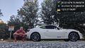
([live picture]Possible closest shot [https://openstreetmap.org/?lat=39.31942240&lon=-76.98037960&zoom=16&layers=B000FTF @39.3194,-76.9804]) |
||
| Line 36: | Line 36: | ||
Image:2021-07-04_39_-76_OfficeLinebacker_1625441322253.jpg|Weigh station nearby. A cop came and asked me if I was okay so probably can't dawdle. [https://openstreetmap.org/?lat=39.31940650&lon=-76.98039700&zoom=16&layers=B000FTF @39.3194,-76.9804] | Image:2021-07-04_39_-76_OfficeLinebacker_1625441322253.jpg|Weigh station nearby. A cop came and asked me if I was okay so probably can't dawdle. [https://openstreetmap.org/?lat=39.31940650&lon=-76.98039700&zoom=16&layers=B000FTF @39.3194,-76.9804] | ||
| + | |||
| + | Image:2021-07-04_39_-76_OfficeLinebacker_1625441344170.jpg|Possible closest shot [https://openstreetmap.org/?lat=39.31942240&lon=-76.98037960&zoom=16&layers=B000FTF @39.3194,-76.9804] | ||
</gallery> | </gallery> | ||
Revision as of 23:29, 4 July 2021
| Sun 4 Jul 2021 in 39,-76: 39.3214275, -76.9844959 geohashing.info google osm bing/os kml crox |
Location
Participants
Plans
Expedition
Tracklog
Photos
Weigh station nearby. A cop came and asked me if I was okay so probably can't dawdle. @39.3194,-76.9804

Possible closest shot @39.3194,-76.9804


Achievements