Difference between revisions of "2022-03-11 50 8"
From Geohashing
(→Location) |
(→Participants) |
||
| Line 19: | Line 19: | ||
<!-- who attended: If you link to your wiki user name in this section, your expedition will be picked up by the various statistics generated for geohashing. You may use three tildes ~ as a shortcut to automatically insert the user signature of the account you are editing with. | <!-- who attended: If you link to your wiki user name in this section, your expedition will be picked up by the various statistics generated for geohashing. You may use three tildes ~ as a shortcut to automatically insert the user signature of the account you are editing with. | ||
--> | --> | ||
| + | * [[User:Karamalz|Karamalz]] | ||
== Plans == | == Plans == | ||
Revision as of 23:47, 11 March 2022
| Fri 11 Mar 2022 in 50,8: 50.2343601, 8.6326822 geohashing.info google osm bing/os kml crox |
Location
In the Hardtwald forest right next to Bad Homburg. 20 meters off the trail.
Participants
Plans
Expedition
Tracklog
Photos
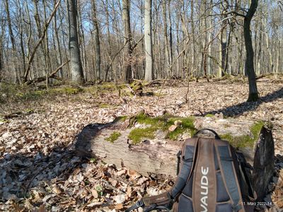
My first attempt to reach a hash point. I walked here on foot from Seulberg on this sunny Friday in early spring. Arrived at the hash point at 14:15. It was a beautiful sunny spot in the forest near Bad Homburg. I sat down on a tree trunk that was placed directly at the coordinates. Stayed there for some time to chill and read a book. At 15:00 I hiked back to the city.
Achievements
