Difference between revisions of "2022-05-27 42 -83"
From Geohashing
ChiefPockets (talk | contribs) (→Expedition) |
m |
||
| Line 11: | Line 11: | ||
| lon=-83 | | lon=-83 | ||
| date=2022-05-27 | | date=2022-05-27 | ||
| + | | retro=1 | ||
}}<!-- edit as necessary --> | }}<!-- edit as necessary --> | ||
__NOTOC__ | __NOTOC__ | ||
| Line 45: | Line 46: | ||
<!-- Add any achievement ribbons you earned below, or remove this section --> | <!-- Add any achievement ribbons you earned below, or remove this section --> | ||
| − | [[Category: | + | [[Category:Retro meetup]] |
[[Category:Expeditions with photos]] | [[Category:Expeditions with photos]] | ||
[[Category:Retro coordinates reached]] | [[Category:Retro coordinates reached]] | ||
{{location|US|MI|OD}} | {{location|US|MI|OD}} | ||
Latest revision as of 19:58, 2 June 2022
| Fri 27 May 2022 in 42,-83: 42.5706839, -83.1716277 geohashing.info google osm bing/os kml crox |
Location
This point is in the drainage ditch or front yard of 1670 McManus.
Participants
Plans
Expedition
Visited 2022-05-28 as part of a multi-stop retro expedition to kick of my Memorial Day weekend! This was my second stop, after 2022-05-23 42 -83 and before 2022-05-25 42 -83.
Tracklog
Photos
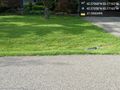
This point is in the drainage ditch or front yard of 1670 McManus. @42.5706,-83.1716
