Difference between revisions of "1998-01-04 53 9"
m (Removed comment) |
m (Changed header) |
||
| Line 1: | Line 1: | ||
| − | {{meetup graticule | + | <!-- If you did not specify these parameters in the template, please substitute appropriate values for IMAGE, LAT, LON, and DATE (YYYY-MM-DD format) |
| + | |||
| + | [[Image:{{{image|IMAGE}}}|thumb|left]] | ||
| + | |||
| + | Remove this section if you don't want an image at the top (left) of your report. You should remove the "Image:" or "File:" | ||
| + | tag from your image file name, and replace the all upper-case word IMAGE in the above line. | ||
| + | |||
| + | And DON'T FORGET to add your expedition and the best photo you took to the gallery on the Main Page! We'd love to read your report, but that means we first have to discover it! :) | ||
| + | -->{{meetup graticule | ||
| lat=53 | | lat=53 | ||
| lon=9 | | lon=9 | ||
| date=1998-01-04 | | date=1998-01-04 | ||
| − | | | + | }}<!-- edit as necessary --> |
| − | }} | + | == Location == |
| + | <!-- where you've surveyed the hash to be --> | ||
| + | |||
| + | == Participants == | ||
| + | <!-- who attended: If you link to your wiki user name in this section, your expedition will be picked up by the various statistics generated for geohashing. You may use three tildes ~ as a shortcut to automatically insert the user signature of the account you are editing with. | ||
| + | --> | ||
| + | |||
| + | == Plans == | ||
| + | <!-- what were the original plans --> | ||
| + | |||
| + | == Expedition == | ||
| + | <!-- how it all turned out. your narrative goes here. --> | ||
| + | |||
| + | == Tracklog == | ||
| + | <!-- if your GPS device keeps a log, you may use Template:Tracklog, post a link here, or both --> | ||
| + | |||
| + | == Photos == | ||
| + | <!-- Insert pictures between the gallery tags using the following format: | ||
| + | Image:2020-##-## ## ## Alpha.jpg | Witty Comment | ||
| + | --> | ||
| + | <gallery perrow="5"> | ||
| + | </gallery> | ||
| + | |||
| + | == Achievements == | ||
| + | {{#vardefine:ribbonwidth|100%}} | ||
| + | <!-- Add any achievement ribbons you earned below, or remove this section --> | ||
| + | |||
| + | __NOTOC__ | ||
| + | <!-- =============== USEFUL CATEGORIES FOLLOW ================ | ||
| + | Delete the next line ONLY if you have chosen the appropriate categories below. If you are unsure, don't worry. People will read your report and help you with the classification. --> | ||
| + | [[Category:New report]] | ||
| + | |||
| + | <!-- ==REQUEST FOR TWITTER BOT== Please leave either the New report or the Expedition planning category in as long as you work on it. This helps the twitter bot a lot with announcing the right outcome at the right moment. --> | ||
| + | |||
| + | <!-- Potential categories. Please include all the ones appropriate to your expedition --> | ||
| + | <!-- If this is a planning page: | ||
| + | [[Category:Expedition planning]] | ||
| + | --> | ||
| + | |||
| + | <!-- If all those plans are never acted upon, change [[Category:Expedition planning]] to [[Category:Not reached - Did not attempt]]. --> | ||
| + | |||
| + | <!-- An actual expedition: | ||
| + | [[Category:Expeditions]] | ||
| + | -- and one or more of -- | ||
| + | [[Category:Expeditions with photos]] | ||
| + | [[Category:Expeditions with videos]] | ||
| + | [[Category:Expedition without GPS]] | ||
| + | --> | ||
| + | |||
| + | <!-- if you reached your coords: | ||
| + | [[Category:Coordinates reached]] | ||
| + | |||
| + | |||
| + | --><!-- or if you failed :( | ||
| + | [[Category:Coordinates not reached]] | ||
| + | -- and a reason -- | ||
| + | When there is a natural obstacle between you and the target: | ||
| + | [[Category:Not reached - Mother Nature]] | ||
| + | |||
| + | When there is a man-made obstacle between you and the target: | ||
| + | [[Category:Not reached - No public access]] | ||
| + | |||
| + | When you failed get your GPS, car, bike or such to work: | ||
| + | [[Category:Not reached - Technology]] | ||
| + | |||
| + | When you went to an alternate location instead of the actual geohash: | ||
| + | [[Category:Not reached - Attended alternate location]] | ||
| + | |||
| + | (Don't forget to delete this final close comment marker) --> | ||
| + | |||
== Location == | == Location == | ||
Revision as of 22:24, 8 July 2023
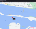
| Sun 4 Jan 1998 in 53,9: 53.5556849, 9.7156781 geohashing.info google osm bing/os kml crox |
Location
Participants
Plans
Expedition
Tracklog
Photos
Achievements
Location
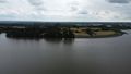
A little bit south of the shore of an island in the middle of the Elbe river.
The city of Wedel (Schleswig-Holstein) lies on the northern river shore and the JVA Hahnöfersand (JVA = Justizvollzugsanstalt = correctional facility) of Jork (Lower Saxony) on the southern one.
Participants
Plans
I wanted to start geohashing for a while now and what better way to start than to get to my Origin geohash first.
Looking it up (which I did via the Shotgun tool because I didn't realize I could go that far back on geohashing.info at first), I found it to be in the middle of the water. But luckily I own a drone and it shouldn't be so far off the coast of Wedel (which would be much easier for me to get to, living in Schleswig-Holstein, than the other shore would be - also, with a prison being on the other side), that the remote wouldn't reach - so I'd make it a Geohash by proxy achievement.
I planned going on Fr. the 30th of June, as I wanted to have a bit of a special date but wouldn't have time on the 1st of July. Then I got the idea to go a bit later, on the 4th of July (today as of writing this) to reach it exactly 25½ years after my birthday, but the weather was forecast to be rainy, which my drone wouldn't like, so Friday it was.
I planned to go by car to somewhere near the beach in Wedel, as public transport from my home town to Wedel isn't great and I didn't have the time to go all the way by bike, as I had other appointments later in the day.
Retro Expedition
Rsge
After I came home from work and had breakfast, I packed my drone and took one last look at the weather forecast. My little brother was using my usual car, so I needed to use my mother's. I got in and started the GPS to the Wedel beach. The drone I had charged while eating, so it's batteries were full - but I realized my phone (which is needed for drone remote viewing) wasn't. Luckily, I put chargers in the family cars, this one included, so I plugged in my phone and started to drive.
Just a few meters from home I realized my phone wasn't charging - the cable was broken - so I looped around and got another cable. Then, on the way again, I mixed up the brake with the clutch, as I'm not used to driving automatic. Then I had to wait ages at the first crossroads, just missing a gap. I briefly considered aborting the whole thing, as it already seemed a bit cursed - but I'm not the superstitious type, so I kept going.
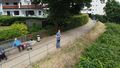
I got to near the beach without further problems and got the last parking spot just a few meters away from the pedestrian walkway to the beach. Going down the walkway I realized it was high on a hillside with stairs leading down to the beach area - and I could just start my drone from there, even having higher range because of being higher up. There were some benches to unpack my drone on, so I started getting it ready. A few retirees were sitting not that far away, but they didn't seem to mind and in fact seemed mildly interested as I connected everything up and started the drone.
I didn't know how to set waypoints by exact coordinates in my drone's app (DJI Fly) and in fact couldn't even get coordinate numbers, as I was still using Shotgun, which as far as I'm aware can't show coordinates on mobile. So I switched to satellite images on Shotgun and DJI Fly and compared location as best I could. Luckily, there was a tidal inlet almost exactly at the location, so it wasn't super inaccurate I hope.
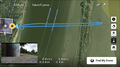
It was a nice day, not too warm, not too cold, clear sky and very little in regards to wind, so the flight went over without any problems. I took a few photos with the drone and a few screenshots of the path and started packing again. While packing, a guy came over and asked me about my drone, so we had a nice short chat about drones, their use and the legal restrictions placed on flying them.
I got back to the car and drove home without any problems.
- For those interested: In Germany, all drones which are not explicitly classified as toys need the following:
- A Haftpflichtversicherung (liability insurance) with explicit inclusion of damage done by drone.
- An e-ID from the LBA (Luftfahrtbundesamt, German federal aviation administration), which is free and just needs insurance and ID confirmation.
- A metallic sign on the drone with at least this e-ID. Name, phone number, etc. are optional.
- The max flight height is 120 m (ca. 400 ft).
- If your drone weighs less than 250 g (ca. 8.8 oz), nothing further is needed. For higher weights you need additional licenses and registrations.
Photos
Screenshot of the map in Shotgun.
Screenshot of the satellite map from DDG.
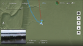
Screenshot from DJI Fly with the drone at the hash position.
Screenshot of the drone's path in DJI Fly.

Straight-down look at the (rough) hash.
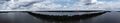
Panorama of the north of the hash.
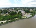
The small terminal to the north of the hash.
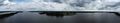
Panorama of the south of the hash.
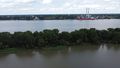
The JVA to the south of the hash.
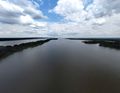
The Elbe river to the east.
The pilot position from a bird's eye view.
Rsge photographing himself.

Panorama from Rsges point of view, looking in the hash's direction.


Achievements
Rsge earned the Origin geohash achievement
|