Difference between revisions of "2024-03-03 28 -82"
From Geohashing
| Line 1: | Line 1: | ||
| − | + | {{meetup graticule | |
| − | |||
| − | |||
| − | |||
| − | |||
| − | |||
| − | |||
| − | |||
| − | |||
| lat=28 | | lat=28 | ||
| lon=-82 | | lon=-82 | ||
| date=2024-03-03 | | date=2024-03-03 | ||
| − | }} | + | }} |
== Location == | == Location == | ||
| − | |||
In a wooded area at the end of Southeast 169th Street | In a wooded area at the end of Southeast 169th Street | ||
== Participants == | == Participants == | ||
| − | + | *[[User:Improv|Improv]] | |
| − | + | *a drag-along | |
| − | [[User:Improv|Improv]] | ||
== Plans == | == Plans == | ||
| − | |||
Drive as close as possible and walk in. | Drive as close as possible and walk in. | ||
== Expedition == | == Expedition == | ||
| − | |||
This didn't work out. Both roads bordering the location had fences with No Trespassing signs. The closest we could get was one-tenth of a mile. | This didn't work out. Both roads bordering the location had fences with No Trespassing signs. The closest we could get was one-tenth of a mile. | ||
| − | |||
| − | |||
| − | |||
== Photos == | == Photos == | ||
| − | |||
| − | |||
| − | |||
<gallery perrow="5"> | <gallery perrow="5"> | ||
Image:Image 20240305 161051 240.jpg | As close as we could get | Image:Image 20240305 161051 240.jpg | As close as we could get | ||
</gallery> | </gallery> | ||
| + | |||
| + | ==Ribbons== | ||
| + | {{no trespassing|date=2024-03-03|latitude=28|longitude=-82|name=[[User:Improv|Improv]]|distance=one-tenth of a mile}} | ||
__NOTOC__ | __NOTOC__ | ||
| − | |||
| − | |||
| − | |||
[[Category:Expeditions]] | [[Category:Expeditions]] | ||
[[Category:Coordinates not reached]] | [[Category:Coordinates not reached]] | ||
[[Category:Not reached - No public access]] | [[Category:Not reached - No public access]] | ||
[[Category:Expeditions with photos]] | [[Category:Expeditions with photos]] | ||
| − | |||
Revision as of 15:04, 16 March 2024
| Sun 3 Mar 2024 in 28,-82: 28.9763065, -82.0494526 geohashing.info google osm bing/os kml crox |
Location
In a wooded area at the end of Southeast 169th Street
Participants
- Improv
- a drag-along
Plans
Drive as close as possible and walk in.
Expedition
This didn't work out. Both roads bordering the location had fences with No Trespassing signs. The closest we could get was one-tenth of a mile.
Photos
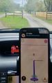
As close as we could get

Ribbons
Improv earned the No trespassing consolation prize
|