Difference between revisions of "2024-08-09 51 6"
From Geohashing
Coyotebush (talk | contribs) ([live picture]Döner in the rain [https://openstreetmap.org/?mlat=51.49083271&mlon=6.98932060&zoom=16 @51.4908,6.9893]) |
Coyotebush (talk | contribs) ([live picture]no access here either [https://openstreetmap.org/?mlat=51.48810556&mlon=6.98519722&zoom=16 @51.4881,6.9852]) |
||
| Line 37: | Line 37: | ||
Image:2024-08-09_51_6_coyotebush_1723203775484.jpg|Döner in the rain [https://openstreetmap.org/?mlat=51.49083271&mlon=6.98932060&zoom=16 @51.4908,6.9893] | Image:2024-08-09_51_6_coyotebush_1723203775484.jpg|Döner in the rain [https://openstreetmap.org/?mlat=51.49083271&mlon=6.98932060&zoom=16 @51.4908,6.9893] | ||
| + | |||
| + | Image:2024-08-09_51_6_coyotebush_1723206742018.jpg|no access here either [https://openstreetmap.org/?mlat=51.48810556&mlon=6.98519722&zoom=16 @51.4881,6.9852] | ||
</gallery> | </gallery> | ||
Revision as of 12:32, 9 August 2024
| Fri 9 Aug 2024 in 51,6: 51.4918039, 6.9879966 geohashing.info google osm bing/os kml crox |
Location
A park in the Vogelheim district of Essen.
Participants
Plans
Train to nearby station Bergeborbeck or Altenessen, then bike.
Expedition
- Transferring at Oberhausen. ETA 13:00 unless I stop for lunch first. -- Coyotebush (talk) @51.4747,6.8521 12:32, 9 August 2024 (GMT+02:00)
Photos
never mind about the creek path @51.4870,6.9800
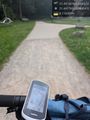
reached by bike @51.4918,6.9880
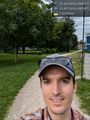
grin @51.4918,6.9880
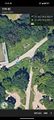
map screenshot
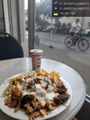
Döner in the rain @51.4908,6.9893
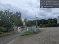
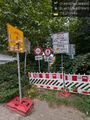
no access here either @51.4881,6.9852


Achievements