Difference between revisions of "2024-08-24 53 8"
From Geohashing
Beardygrade (talk | contribs) (→Location) |
Beardygrade (talk | contribs) ([retro picture]The wet, grassy field underlying the geohash.) |
||
| Line 32: | Line 32: | ||
Image:2024-08-24_53_8_beardygrade_1724538425515.jpg|Proof of reaching the geohash. | Image:2024-08-24_53_8_beardygrade_1724538425515.jpg|Proof of reaching the geohash. | ||
| + | |||
| + | Image:2024-08-24_53_8_beardygrade_1724712681639.jpg|The wet, grassy field underlying the geohash. | ||
</gallery> | </gallery> | ||
Revision as of 22:51, 26 August 2024
| Sat 24 Aug 2024 in 53,8: 53.1421114, 8.4906792 geohashing.info google osm bing/os kml crox |
Location
The geohash was located in a wet, grassy rural landscape (Hiddigwardermoor) between Hude and the small river Ollen. It was more or less in the center of a field accessible from the road.
Participants
Plans
Expedition
Tracklog
Photos

Proof of reaching the geohash.
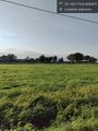
The wet, grassy field underlying the geohash.


Achievements