Difference between revisions of "2008-08-16 48 -123"
imported>Thepiguy (Categories added) |
imported>Thepiguy (Pictures added) |
||
| Line 25: | Line 25: | ||
The ride back was good, and took considerably less time than on the way there. I ate dinner on the ferry and enjoyed a sunset from the middle of the Georgia Straight. I arrived back in Tsawassen at 2130 and biked the rest of the way home in the dark. | The ride back was good, and took considerably less time than on the way there. I ate dinner on the ferry and enjoyed a sunset from the middle of the Georgia Straight. I arrived back in Tsawassen at 2130 and biked the rest of the way home in the dark. | ||
| − | + | ==Images== | |
| − | < | + | <gallery widths="150px" heights="100px" perrow="5"> |
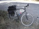
| + | Image:2008-08-16 48 -123 bike.jpg|Here's the new bike waiting for the shuttle. | ||
| + | Image:2008-08-16 48 -123 ferry.jpg|On the boat to Victoria! | ||
| + | Image:2008-08-16 48 -123 bridge.jpg|One of the countless wooden bridges on the trails. Amazing! | ||
| + | Image:2008-08-16 48 -123 hash.jpg|The hash was obviously on private property, but still a great view! | ||
| + | Image:2008-08-16 48 -123 camp.jpg|Here was my outpost by the side of the road. | ||
| + | Image:2008-08-16 48 -123 trash.jpg| Big 'ol bag of geotrash. | ||
| + | Image:2008-08-16 48 -123 me.jpg|I finally put the automatic timer to good use! | ||
| + | Image:2008-08-16 48 -123 xkcd.jpg|My marker for any future travelers. | ||
| + | Image:2008-08-16 48 -123 tunnel.jpg|One of the cool tunnels on the way back. | ||
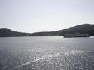
| + | Image:2008-08-16 48 -123 sunset.jpg|The sunset on the ferry home. | ||
| + | </gallery> | ||
[[Category:Expeditions]] | [[Category:Expeditions]] | ||
Revision as of 02:30, 19 August 2008
| Sat 16 Aug 2008 in 48,-123: 48.3351359, -123.6121764 geohashing.info google osm bing/os kml crox |
Not content with sitting at home on the weekend, thepiguy hauled himself and his new bike 170km to Vancouver island and back!
Details
The hash point was located on the southern portion of Vancouver island. It appeared to be on private property, but the local road passed very close by and looked out over the water and point itself.
Although I only made it to within 150m of the geohash, I had a super awesome day!
The Expedition
I set out bright and early at 0700 hours and biked through Stevston to the tunnel's bike shuttle stop. I'd never taken the free shuttle before, and I'm not sure what I expected. What I got was a middle aged Indian man with sketchy van and trailer. Few words were exchanged between me and shuttle driver but we made the 10 minute trip through the tunnel and the afore mentioned van only stalled once!
I made it to the Tsawassen ferry terminal for 0900, leaving me with a large wait for the 1000 to Schwartz Bay abored the "Queen of Much-needed-repair." The ride itself was uneventful, (save for my delicious Belgian Waffle!) and I ended up sleeping most of the way.
I arrived on the island at 1145 and quickly made the greatest discovery of the day. While I had exquisitely crafted a google-mapsterpiece the night before, it turns out that Victoria has an amazing system of bike paths that span hundreds of kilometers! Even though I had no idea what sort of condition these paths were in, I threw caution to the wind, discarded my map and began to blindly follow any sign that had a picture of a bike on it!
This turned out to be the best possible decisions I could have made; these trails are amazing! I followed the Lochside route until it met up with the Galloping Goose. They were a mix of quiet on-street paths, lightly forested gravel trails, paved bike lanes next to highways and shortcuts through fields. In addition, there were numerous wooden trestles, large tunnels and more than enough signs to keep even the most distracted cyclist on track. It was amazing!
I made it to my destination at 1530 and set up camp. As I had suspected the hash point was located on private property (a nice ocean view home) but the highway looking out over the water was withing 150m and had a good view of the point. I hung around for an hour, eating lunch, taking pictures, and picking up garbage. Several people stopped at the side of the road, one car to inquire if I had seen their lost dog and another just to admire the view, but alas; no geohashers in sight.
I marked the territory (with the letters xkcd, what were you thinking of?) took a few last shots and proceeded on my way.
The ride back was good, and took considerably less time than on the way there. I ate dinner on the ferry and enjoyed a sunset from the middle of the Georgia Straight. I arrived back in Tsawassen at 2130 and biked the rest of the way home in the dark.
Images

Here's the new bike waiting for the shuttle.
On the boat to Victoria!
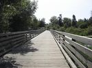
One of the countless wooden bridges on the trails. Amazing!
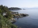
The hash was obviously on private property, but still a great view!
Here was my outpost by the side of the road.

Big 'ol bag of geotrash.
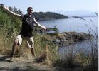
I finally put the automatic timer to good use!

My marker for any future travelers.
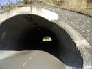
One of the cool tunnels on the way back.
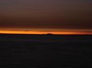
The sunset on the ferry home.


