Difference between revisions of "2008-10-18 35 -106"
imported>Bishop Wash (New page: {{meetup graticule | map=<map lat="35" lon="-106" date="2008-10-18" /> | lat=35 | lon=-106 | date=2008-10-18 }} == Expedition == '''Bishop_Wash:''' Today I initially failed attempting th...) |
imported>ReletBot m (Failed => Not reached) |
||
| Line 22: | Line 22: | ||
[[Category:Expeditions with photos]] | [[Category:Expeditions with photos]] | ||
[[Category:Coordinates not reached]] | [[Category:Coordinates not reached]] | ||
| − | [[Category: | + | [[Category:Not reached - No public access]] |
Revision as of 20:32, 31 March 2009
| Sat 18 Oct 2008 in 35,-106: 35.0236881, -106.3062578 geohashing.info google osm bing/os kml crox |
Expedition
Bishop_Wash: Today I initially failed attempting the Grants, New Mexico geohash. I'd looked at the Albuquerque geohash and thought it was obtainable. However, I wanted a shot at a virgin graticule achievement in the Grants graticule. Once I reached an obstacle with that one, I thought I'd give the Albuquerque geohash a shot. Both hashes were close to I-40, so it wasn't much of a problem.
Nearing the geohash I ended off paved roads on onto some rough dirt roads. It was interesting trying to reach the coordinates. I finally pulled off a street spur, near a house, and was ~.3 miles from the coordinates. A seemingly coincidental number today. The geohash was in what appeared to be an open field. I gathered my camera and GPS unit and headed off to reach the coordinates. In a short while I reached a fence. There weren't any signs, but I didn't think I should proceed. I took a picture of the fence and the screen of the GPS showing that I was .22 miles from the geohash. Zero for two on attempts today. Maybe tomorrow will be better.
Pictures
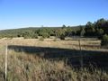
The fence preventing me from reaching the geohash
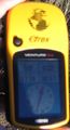
Showing I was .22 miles from the geohash

