Difference between revisions of "Category:Irish Sea"
From Geohashing
imported>Benjw (creating Irish Sea page) |
imported>Fippe |
||
| Line 5: | Line 5: | ||
As there is no bridge or tunnel alternative to crossing the Irish Sea, about 12 million people cross by ferries each year, very few of them geohashers. | As there is no bridge or tunnel alternative to crossing the Irish Sea, about 12 million people cross by ferries each year, very few of them geohashers. | ||
| − | The Irish Sea is relatively small, | + | The Irish Sea is relatively small, and does not contain a single graticule that is wholly water. However, the [[Lambay Island East, Ireland|Lambay Island East]] graticule and the [[Fishguard, United Kingdom|Fishguard]] graticule are over 99% water. |
[[Category:Graticules by body of water]] | [[Category:Graticules by body of water]] | ||
Latest revision as of 10:14, 9 August 2018
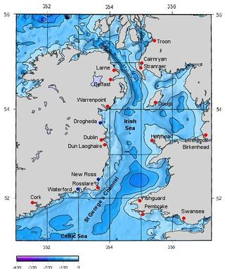
The Irish Sea is a body of salt water, which separates the two islands of Great Britain and Ireland in north-west Europe. It connects to the Atlantic Ocean by the St George's Channel in the south, and the North Channel in the north. It also contains the islands of Anglesey and the Isle of Man.
As there is no bridge or tunnel alternative to crossing the Irish Sea, about 12 million people cross by ferries each year, very few of them geohashers.
The Irish Sea is relatively small, and does not contain a single graticule that is wholly water. However, the Lambay Island East graticule and the Fishguard graticule are over 99% water.
Pages in category "Irish Sea"
The following 15 pages are in this category, out of 15 total.
