Difference between revisions of "2008-05-21 37 -121"
From Geohashing
imported>Zigdon (New page: <map lat="37" lon="-121" date="2008-05-21" width="300" height="300"/> == About == These coordinates were located in the East Bay, California graticule on 2008-05-21, in the Santa...) |
imported>Relsqui (added photo) |
||
| Line 1: | Line 1: | ||
<map lat="37" lon="-121" date="2008-05-21" width="300" height="300"/> | <map lat="37" lon="-121" date="2008-05-21" width="300" height="300"/> | ||
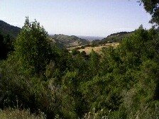
| + | [[Image:Eastbayca-may21.jpg|frame|right]] | ||
== About == | == About == | ||
Revision as of 02:05, 22 May 2008
<map lat="37" lon="-121" date="2008-05-21" width="300" height="300"/>
About
These coordinates were located in the East Bay, California graticule on 2008-05-21, in the Santa Cruz mountains.
37.179468°, -121.861536°
Not quite reachable from the road, we got within 150m of the actual point.
People
People who reached these coordinates:
