Difference between revisions of "2009-07-14 49 -122"
From Geohashing
imported>Rhonda m (→Participants: format) |
imported>Rhonda (→Photos) |
||
| Line 31: | Line 31: | ||
== Photos == | == Photos == | ||
| − | <gallery | + | <gallery> |
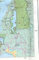
| − | Image:2009- | + | Image:2009-07-14_49_-122_map.jpeg|map |
| − | |||
</gallery> | </gallery> | ||
<!-- Potential categories. Please include all the ones appropriate to your expedition --> | <!-- Potential categories. Please include all the ones appropriate to your expedition --> | ||
| − | |||
[[Category:Expedition planning]] | [[Category:Expedition planning]] | ||
| − | |||
<!-- An actual expedition: | <!-- An actual expedition: | ||
Revision as of 18:01, 14 July 2009
| Tue 14 Jul 2009 in 49,-122: 49.3504257, -122.8322685 geohashing.info google osm bing/os kml crox |
Location
In the Siskin Lake/Robin Lake area, east of Buntzen Lake on top of a mountain. There are established hiking trails there.
Participants
Plans
Meet after work (leaving as early as possible) and drive to Buntzen Lake picnic area. Hike ~4km on a trail (note: switchbacks), find hash point, hike down.
Sunset is at 9:13PM. We're bringing headlamps and jackets (and emergency gear) in case we're returning in the dark. Weather forecast calls for clearing skies through the day.
Expedition
Tracklog
Photos
map
