Difference between revisions of "2009-07-25 42 -72"
imported>Sara (expand the subst:Expedition) |
(Just sit right back and you'll hear a tale...) |
||
| Line 1: | Line 1: | ||
| − | |||
<!-- If you did not specify these parameters in the template, please substitute appropriate things for IMAGE, LAT, LON, and DATE (YYYY-MM-DD format) --> | <!-- If you did not specify these parameters in the template, please substitute appropriate things for IMAGE, LAT, LON, and DATE (YYYY-MM-DD format) --> | ||
<!-- | <!-- | ||
| − | [[Image:{{{image| | + | [[Image:{{{image|2009-07-25_42_-72_kids.jpg}}}|thumb|left]] |
--> | --> | ||
{{meetup graticule | {{meetup graticule | ||
| lat=42 | | lat=42 | ||
| lon=-72 | | lon=-72 | ||
| − | | date=2009-07- | + | | date=2009-07-25 |
}} | }} | ||
| Line 14: | Line 13: | ||
== Location == | == Location == | ||
| + | In Harriman Reservoir, in southern Vermont. This would have been a water geohash. We tried to get there by canoe, and didn't make it, but had a great day anyway. | ||
== Participants == | == Participants == | ||
| + | [[User:Sara|Sara]] with her daughter and son. | ||
| + | |||
| + | == Expedition == | ||
| + | |||
| + | We had to try for this hash, because it was in Vermont, and a water geohash would have finished my four-state reverse regional achievement in style, but I knew before we started that it was unlikely we'd make it to the hashpoint, and indeed we didn't. | ||
| − | + | The hashpoint was about 2/3 of the way south in Harriman Reservoir, a serpentine lake in southern Vermont. The problem is that the only place to rent a canoe on the reservoir is at the northern tip of the reservoir, and the reservoir is so curvy that one would have to paddle about (... we pause here for English-to-metric conversion...) 8 km to get to the hashpoint from the canoe rental place, and I don't really know how to control a canoe. We tried anyway, though, and had a great day. | |
| + | If it weren't for geohashing, it's unlikely that I would ever have taken my kids canoeing at all. | ||
| − | + | We started out two hours later than I wanted to, which is about typical for us. The road from the Interstate to the reservoir was pretty, and full of tourist shops selling cheese and maple syrup. We rented a canoe in Wilmington, VT and the kids got little kid-sized wooden paddles, which was great because we didn't have to worry about a full-sized paddle going overboard, and they could help paddle without wearing themselves out or whacking each other. | |
| + | |||
| + | The weather was great and the lake was beautiful. It would have been even better with fewer motorboats, but it was still great. | ||
| + | |||
| + | As I said, I started the day not knowing how to control a canoe. Most of my effort seemed to just make the canoe turn on its own axis. I kept having to move the paddle from one side of the canoe to the other, but I only hit my son in the head with the paddle once before we figured out that he ought to sit farther forward. After an hour, we had progressed only about 1km. Actually, we had covered much more distance than that, zigzagging around, but we were maybe 1km from where we started, and it was clear there was no way we were going to make it to the hashpoint and back that afternoon. We turned back after about an hour and forty five minutes. By the end of the afternoon, I wasn't much better at steering a canoe than I was at the beginning, but we did manage to get back to the place where we started without hitting anything significant. The kids had a great attitude the whole time. | ||
| + | We returned our rented gear and then ate dinner at a restaurant where they made really good ice cream on the premises, which you can eat while watching the cars on the road, which is a big plus for my son. Then we drove home. | ||
| − | + | (By the way, renting a canoe somewhere else and driving it to a place on the shoreline nearer to the hashpoint would not have been possible for me and the kids. We had to rent the canoe right on the reservoir, because it was all I could do to get the canoe across the street from the rental place and into the water - I could never have gotten a canoe on and off the top of the car and from the road to the shoreline) | |
| + | I'm calling this "Not reached - Technology" because I think we could have made it with a kayak. | ||
== Photos == | == Photos == | ||
| − | + | My daughter took most of these pictures. | |
| − | <gallery perrow=" | + | <gallery perrow="4"> |
| − | Image:2009- | + | Image:2009-07-25_42_-72_playground.jpg | When we stopped at a rest area on the way to the hashpoint, the kids noticed it had a playground. |
| − | Image:2009- | + | Image:2009-07-25_42_-72_kids.jpg | My son got a lifejacket with wild animals on it. The lake was beautiful. |
| + | Image:2009-07-25_42_-72_boat.jpg | There were a lot of motorboats, and therefore we saw hardly any nonhuman animals. The kids took pictures of a lot of the motorboats. | ||
| + | Image:2009-07-25_42_-72_wake.jpg | However, the kids didn't like the waves the motorboats made. We kept having to turn the canoe parallel to the waves. I don't understand why people would use a motorboat for fun, mostly because I don't understand the burning of so much fossil fuel for fun, but of course I drove 250 km today just so I could paddle a canoe. | ||
| + | Image:2009-07-25_42_-72_sail.jpg | The kids loved seeing this sailboat and taking pictures of it. | ||
</gallery> | </gallery> | ||
| − | |||
| − | |||
| − | |||
| − | |||
| − | |||
| − | |||
| − | |||
[[Category:Expeditions]] | [[Category:Expeditions]] | ||
[[Category:Expeditions with photos]] | [[Category:Expeditions with photos]] | ||
| − | |||
| − | |||
| − | |||
| − | |||
| − | |||
| − | |||
| − | |||
| − | |||
| − | |||
[[Category:Coordinates not reached]] | [[Category:Coordinates not reached]] | ||
| − | |||
| − | |||
| − | |||
[[Category:Not reached - Technology]] | [[Category:Not reached - Technology]] | ||
| − | |||
| − | |||
Revision as of 02:55, 26 July 2009
| Sat 25 Jul 2009 in 42,-72: 42.8168510, -72.9049259 geohashing.info google osm bing/os kml crox |
Location
In Harriman Reservoir, in southern Vermont. This would have been a water geohash. We tried to get there by canoe, and didn't make it, but had a great day anyway.
Participants
Sara with her daughter and son.
Expedition
We had to try for this hash, because it was in Vermont, and a water geohash would have finished my four-state reverse regional achievement in style, but I knew before we started that it was unlikely we'd make it to the hashpoint, and indeed we didn't.
The hashpoint was about 2/3 of the way south in Harriman Reservoir, a serpentine lake in southern Vermont. The problem is that the only place to rent a canoe on the reservoir is at the northern tip of the reservoir, and the reservoir is so curvy that one would have to paddle about (... we pause here for English-to-metric conversion...) 8 km to get to the hashpoint from the canoe rental place, and I don't really know how to control a canoe. We tried anyway, though, and had a great day.
If it weren't for geohashing, it's unlikely that I would ever have taken my kids canoeing at all.
We started out two hours later than I wanted to, which is about typical for us. The road from the Interstate to the reservoir was pretty, and full of tourist shops selling cheese and maple syrup. We rented a canoe in Wilmington, VT and the kids got little kid-sized wooden paddles, which was great because we didn't have to worry about a full-sized paddle going overboard, and they could help paddle without wearing themselves out or whacking each other.
The weather was great and the lake was beautiful. It would have been even better with fewer motorboats, but it was still great.
As I said, I started the day not knowing how to control a canoe. Most of my effort seemed to just make the canoe turn on its own axis. I kept having to move the paddle from one side of the canoe to the other, but I only hit my son in the head with the paddle once before we figured out that he ought to sit farther forward. After an hour, we had progressed only about 1km. Actually, we had covered much more distance than that, zigzagging around, but we were maybe 1km from where we started, and it was clear there was no way we were going to make it to the hashpoint and back that afternoon. We turned back after about an hour and forty five minutes. By the end of the afternoon, I wasn't much better at steering a canoe than I was at the beginning, but we did manage to get back to the place where we started without hitting anything significant. The kids had a great attitude the whole time.
We returned our rented gear and then ate dinner at a restaurant where they made really good ice cream on the premises, which you can eat while watching the cars on the road, which is a big plus for my son. Then we drove home.
(By the way, renting a canoe somewhere else and driving it to a place on the shoreline nearer to the hashpoint would not have been possible for me and the kids. We had to rent the canoe right on the reservoir, because it was all I could do to get the canoe across the street from the rental place and into the water - I could never have gotten a canoe on and off the top of the car and from the road to the shoreline)
I'm calling this "Not reached - Technology" because I think we could have made it with a kayak.
Photos
My daughter took most of these pictures.
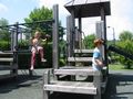
When we stopped at a rest area on the way to the hashpoint, the kids noticed it had a playground.
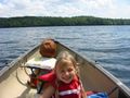
My son got a lifejacket with wild animals on it. The lake was beautiful.
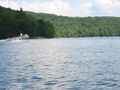
There were a lot of motorboats, and therefore we saw hardly any nonhuman animals. The kids took pictures of a lot of the motorboats.
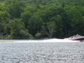
However, the kids didn't like the waves the motorboats made. We kept having to turn the canoe parallel to the waves. I don't understand why people would use a motorboat for fun, mostly because I don't understand the burning of so much fossil fuel for fun, but of course I drove 250 km today just so I could paddle a canoe.
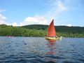
The kids loved seeing this sailboat and taking pictures of it.


