Difference between revisions of "User:B0rken"
imported>Theduffman |
imported>Theduffman |
||
| Line 5: | Line 5: | ||
:I agree totally, a smaller graticule closer around the CBD and surrounding suburbs would be much better. Too much bush! [[user:zorg|zorg]] | :I agree totally, a smaller graticule closer around the CBD and surrounding suburbs would be much better. Too much bush! [[user:zorg|zorg]] | ||
| − | |||
Well the point was I guess that we can still use both degree box graticule things ... just fudge the data a bit so we don't get muddy boots. Leave that to the 'hardcore' geocachers. | Well the point was I guess that we can still use both degree box graticule things ... just fudge the data a bit so we don't get muddy boots. Leave that to the 'hardcore' geocachers. | ||
| Line 18: | Line 17: | ||
[[Image:Bump-sat.jpg|thumb|300 px|]] | [[Image:Bump-sat.jpg|thumb|300 px|]] | ||
A revision of the Melbourne Graticule centering it closer to the CBD, and halving its height. Roughly 1/16th of this half- graticule is over water. Coords are -37.5 144.5, -37.5 145.5, -38 144.5, -38 144.5 . | A revision of the Melbourne Graticule centering it closer to the CBD, and halving its height. Roughly 1/16th of this half- graticule is over water. Coords are -37.5 144.5, -37.5 145.5, -38 144.5, -38 144.5 . | ||
| + | |||
| + | :I'm all for setting ourselves up with a slice a segment of a circle as a graticule in the long-term [[user:theduffman|theduffman]] | ||
Latest revision as of 03:30, 19 June 2008
I think that the Melbourne formula should include the following modifications
1. a Log [1] function to skew results towards the CBD so we see more interesting places and less bush, (as fun as the bush can be) [2]
2. ASX 200 [3] data, not the DOW [4]. Oi oi oi.
- I agree totally, a smaller graticule closer around the CBD and surrounding suburbs would be much better. Too much bush! zorg
Well the point was I guess that we can still use both degree box graticule things ... just fudge the data a bit so we don't get muddy boots. Leave that to the 'hardcore' geocachers.
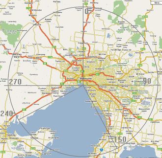
Given Melbourne's radial shape - why not use polar coordinates, with a wedge-shaped exclusion area for Port Philip Bay ... this would include the largest amount of homies with the least amount of bush time. Or am I reinventing the wheel here ... I just figure that if we're going to f$ck around with the math to take the Sacred Dow's opening stat into consideration, we might as well do something about our schizophrenic graticules.
I have no idea how to implement this - only that it can be done ... The other option would be to use a half-graticule, centered over the CBD.
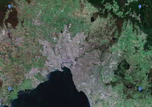
A revision of the Melbourne Graticule centering it closer to the CBD, and halving its height. Roughly 1/16th of this half- graticule is over water. Coords are -37.5 144.5, -37.5 145.5, -38 144.5, -38 144.5 .
- I'm all for setting ourselves up with a slice a segment of a circle as a graticule in the long-term theduffman

