Difference between revisions of "2009-09-15 48 9"
From Geohashing
imported>Ekorren (creating planning page, although not sure whether I want to go.) |
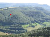
imported>Ekorren (→Location: Aerial image of location, as seen from the Rossberg tower) |
||
| Line 7: | Line 7: | ||
== Location == | == Location == | ||
| − | Near Mössingen-Öschingen, in the forest on the very steep slope to the Meisenbühl mountain. There might even be cliffs. Significant risk of inaccessibility - MNB. | + | Near Mössingen-Öschingen, in the forest on the very steep slope to the Meisenbühl mountain. There might even be cliffs. Significant risk of inaccessibility - MNB. |
| − | By bike it's about 17 km from Tübingen, buses go at least once per hour from Mössingen and Reutlingen to Öschingen. | + | [[Image:2009-09-15_48_9_Location.jpg|201px]] |
| + | |||
| + | By bike it's about 17 km from Tübingen, buses go at least once per hour from Mössingen and Reutlingen to Öschingen. | ||
== Participants == | == Participants == | ||
Revision as of 17:41, 14 September 2009
| Tue 15 Sep 2009 in 48,9: 48.4057106, 9.1249051 geohashing.info google osm bing/os kml crox |
Contents
Location
Near Mössingen-Öschingen, in the forest on the very steep slope to the Meisenbühl mountain. There might even be cliffs. Significant risk of inaccessibility - MNB.
By bike it's about 17 km from Tübingen, buses go at least once per hour from Mössingen and Reutlingen to Öschingen.
Participants
ekorren considers trying it anyway.
