Difference between revisions of "2009-12-10 45 -123"
imported>Jiml (Fill in a few details.) |
imported>Jiml (Add to report) |
||
| Line 9: | Line 9: | ||
== Participants == | == Participants == | ||
| − | * Jim | + | * [[User:Jiml|Jim]] |
== Plans == | == Plans == | ||
| Line 17: | Line 17: | ||
| − | + | == Expedition == | |
| + | I went out as part of my trip to run errands. It's been quite cold in the Pacific Northwest lately, but not | ||
| + | cloudy, so it has very pretty. Easily got to Dixon Mill Road and started down it. Partway | ||
| + | down, I realized this is the second hashpoint there in a few months, and on the way there, I passed the driveway | ||
| + | to the previous property. | ||
| − | + | I continued on, going around curves, glancing at the GPS and thinking: "It says it is off that way, but I think the road | |
| + | comes around". And sure enough, the road does swing around. Luckily, there was only one road in the | ||
| + | area, so I didn't have to worry about taking a turn. :-) | ||
| + | Finally, the distance drops to about a third of a mile and does go any lower. I look around, and there isn't anyway closer without crossing someone's property. I finally find someone tending a burn pile and ask about access "about a half mile | ||
| + | in that direction". He says his property ends at the slightly visible fence line, and | ||
| + | tells me how to find the owner of the next section of land. | ||
| − | + | However, the directions didn't work. I give up and declare it as "Posted". But it was a pretty drive, and | |
| + | I have a few photos. My navigator slept in the back of the car, so I was on my own. She had her coat on, so | ||
| + | she was able to stay warm. | ||
== Photos == | == Photos == | ||
| − | |||
<gallery perrow="4"> | <gallery perrow="4"> | ||
| − | Image:2009- | + | |
| − | Image:2009- | + | Image:2009-12-10_45_-123-field2.jpg | View down the hill on the other side of the road |
| + | Image:2009-12-10_45_-123-field1.jpg | View down the hill on the same side as the hashpoint | ||
| + | Image:2009-12-10_45_-123-posted.jpg | One of several no-access indicators | ||
| + | |||
| + | |||
</gallery> | </gallery> | ||
| − | |||
| − | |||
| − | |||
| − | |||
| − | |||
| − | + | [[Category:Expeditions]] | |
| − | |||
| − | |||
| − | |||
[[Category:Expeditions with photos]] | [[Category:Expeditions with photos]] | ||
| − | |||
| − | |||
| − | |||
| − | |||
| − | |||
| − | |||
| − | |||
| − | |||
[[Category:Coordinates not reached]] | [[Category:Coordinates not reached]] | ||
| − | |||
| − | |||
[[Category:Not reached - No public access]] | [[Category:Not reached - No public access]] | ||
| − | |||
| − | |||
| − | |||
| − | |||
| − | |||
| − | |||
Revision as of 04:52, 11 December 2009
| Thu 10 Dec 2009 in 45,-123: 45.4419478, -123.0838128 geohashing.info google osm bing/os kml crox |
Contents
Location
Dixon Mill Road, apparently in Gaston, Oregon
Participants
Plans
As expected, it appears on forest land. I'm going to go take a look and see if I can get there, but I'm not holding out too much hope.
Expedition
I went out as part of my trip to run errands. It's been quite cold in the Pacific Northwest lately, but not cloudy, so it has very pretty. Easily got to Dixon Mill Road and started down it. Partway down, I realized this is the second hashpoint there in a few months, and on the way there, I passed the driveway to the previous property.
I continued on, going around curves, glancing at the GPS and thinking: "It says it is off that way, but I think the road comes around". And sure enough, the road does swing around. Luckily, there was only one road in the area, so I didn't have to worry about taking a turn. :-)
Finally, the distance drops to about a third of a mile and does go any lower. I look around, and there isn't anyway closer without crossing someone's property. I finally find someone tending a burn pile and ask about access "about a half mile in that direction". He says his property ends at the slightly visible fence line, and tells me how to find the owner of the next section of land.
However, the directions didn't work. I give up and declare it as "Posted". But it was a pretty drive, and I have a few photos. My navigator slept in the back of the car, so I was on my own. She had her coat on, so she was able to stay warm.
Photos
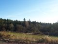
View down the hill on the other side of the road
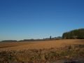
View down the hill on the same side as the hashpoint
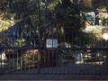
One of several no-access indicators


