Difference between revisions of "2009-12-25 43 -124"
imported>Michael5000 |
imported>Michael5000 (Finally, photos.) |
||
| Line 27: | Line 27: | ||
== Photos == | == Photos == | ||
| − | |||
<gallery perrow="4"> | <gallery perrow="4"> | ||
| − | Image: | + | Image:12-25-10 43 -124 gully1.jpg | I'm stopped by a gully and barbed wire... |
| − | Image: | + | Image:12-25-10 43 -124 gully2.jpg | ...but keep my savoir faire. |
| + | Image:12-25-10 43 -124 Mrs in Road.jpg | Mrs.5000 on the country lane. | ||
| + | Image:12-25-10 43 -124 hash.jpg| The hash point is over yonder in those fields. | ||
| + | Image:12-25-10 43 -124 us.jpg| Mrs. and Michael5000. | ||
| + | Image:12-25-10 43 -124 the bear.jpg| Cinnamon Bear enjoying the rural vibe. | ||
</gallery> | </gallery> | ||
| − | |||
Revision as of 03:35, 1 January 2010
| Fri 25 Dec 2009 in 43,-124: 43.1097057, -124.0871796 geohashing.info google osm bing/os kml crox |
Location
North of Myrtle Point, off of Sitkum Lane.
Participants
Expedition
Hoping to make the first successful hash of the graticule, we left Bandon on the mid-afternoon of a sunny Christmas Day. Several country lanes later, we arrived at an intersection of two remote gravel roads, only 20 meters or so from the hashpoint. Unfortunately, between it and us was a battered barbed-wire fence and, perhaps more to the point, a small but deep gully with a brisk stream running along the bottom of it. We took a few pictures, and continued our Christmas drive through the backroads.
Photos
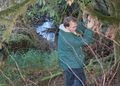
I'm stopped by a gully and barbed wire...
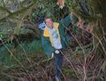
...but keep my savoir faire.
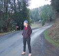
Mrs.5000 on the country lane.
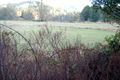
The hash point is over yonder in those fields.

Mrs. and Michael5000.
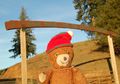
Cinnamon Bear enjoying the rural vibe.


