Difference between revisions of "2010-01-15 35 -101"
imported>Redassag02 m (→Expedition) |
|||
| Line 1: | Line 1: | ||
| − | |||
<!-- If you did not specify these parameters in the template, please substitute appropriate things for IMAGE, LAT, LON, and DATE (YYYY-MM-DD format) | <!-- If you did not specify these parameters in the template, please substitute appropriate things for IMAGE, LAT, LON, and DATE (YYYY-MM-DD format) | ||
| Line 34: | Line 33: | ||
| − | |||
[[Category:New report]] | [[Category:New report]] | ||
| − | |||
| − | |||
| − | |||
| − | |||
| − | |||
| − | |||
| − | |||
[[Category:Expeditions]] | [[Category:Expeditions]] | ||
| − | |||
[[Category:Expeditions with photos]] | [[Category:Expeditions with photos]] | ||
| − | |||
| − | |||
| − | |||
| − | |||
| − | |||
| − | |||
| − | |||
| − | |||
| − | |||
| − | |||
[[Category:Not reached - No public access]] | [[Category:Not reached - No public access]] | ||
Revision as of 09:23, 17 January 2010
| Fri 15 Jan 2010 in 35,-101: 35.2817822, -101.9728271 geohashing.info google osm bing/os kml crox |
Location
Private ranch northwest of Amarillo.
Participants
Redassag02 +1
Plans
Noticed a close hash just before lunch and picked up a friend to check this whole thing out.
Expedition
I stumbled upon Geo Hashing on Monday morning and noticed my graticule had no information posted. "Ripe for the taking," I thought. During the week, I had to break out the old TomTom, download a few iPhone apps, and figure out a general game plan. I noticed Friday right before lunch that the hash wasn't too far and close to a "road", so what better time than now to check it out? I convinced a friend who had never heard of this weirdness to come along. Reached the first turnoff in about five minutes and wouldn't you know it, there was no such road as shown on Google Maps? Made a couple U-turns and headed down a ranch road that might have gotten us close but alas, a padlocked gate barred the way. Oh well, it was an easy first try. With so much open space around, you can probably expect a lot more dead end posts.
Photos
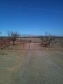
First hashing foiled
