Difference between revisions of "2010-04-06 45 -123"
From Geohashing
imported>Jiml (Fill in some data) |
imported>Jiml (Expnd report) |
||
| Line 1: | Line 1: | ||
| − | |||
| − | |||
| − | |||
| − | |||
| − | |||
| − | |||
{{meetup graticule | {{meetup graticule | ||
| lat=45 | | lat=45 | ||
| Line 24: | Line 18: | ||
== Expedition == | == Expedition == | ||
| − | + | I found my way there, and it was a field full of grapevines, so no access to the | |
| + | hashpoint. On the way I ran into another graveyard, so I took a picture for my | ||
| + | continuing series "The graveyards of Washington County". | ||
| + | |||
| + | I took a couple of pictures and I continued on to home to make dinner. | ||
| − | |||
| − | |||
== Photos == | == Photos == | ||
| − | + | ||
| − | |||
| − | |||
<gallery perrow="4"> | <gallery perrow="4"> | ||
| + | Image:2010-04-06_45_-123-graveyard.jpg | A nearby graveyard | ||
| + | Image:2010-04-06_45_-123-hashpoint.jpg | A view of the hashpoint | ||
</gallery> | </gallery> | ||
| Line 39: | Line 35: | ||
[[Category:Expeditions]] | [[Category:Expeditions]] | ||
| − | |||
[[Category:Expeditions with photos]] | [[Category:Expeditions with photos]] | ||
| − | |||
| − | |||
| − | |||
| − | |||
| − | |||
| − | |||
| − | |||
[[Category:Coordinates not reached]] | [[Category:Coordinates not reached]] | ||
| − | |||
| − | |||
[[Category:Not reached - No public access]] | [[Category:Not reached - No public access]] | ||
| − | |||
| − | |||
| − | |||
Revision as of 06:07, 7 April 2010
| Tue 6 Apr 2010 in 45,-123: 45.6020716, -123.0849708 geohashing.info google osm bing/os kml crox |
Location
South and West of North Plains, Oregon
Participants
- Jim
Plans
Jim is going to go and expects to find a field with no access.
Expedition
I found my way there, and it was a field full of grapevines, so no access to the hashpoint. On the way I ran into another graveyard, so I took a picture for my continuing series "The graveyards of Washington County".
I took a couple of pictures and I continued on to home to make dinner.
Photos
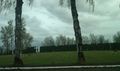
A nearby graveyard
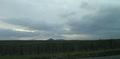
A view of the hashpoint

