Difference between revisions of "2010-07-06 52 -2"
From Geohashing
imported>Jstanley (Created page) |
imported>Jstanley (Sorted out gallery section) |
||
| Line 1: | Line 1: | ||
| − | |||
<!-- If you did not specify these parameters in the template, please substitute appropriate things for IMAGE, LAT, LON, and DATE (YYYY-MM-DD format) | <!-- If you did not specify these parameters in the template, please substitute appropriate things for IMAGE, LAT, LON, and DATE (YYYY-MM-DD format) | ||
| Line 11: | Line 10: | ||
| date=2010-07-06 | | date=2010-07-06 | ||
}} | }} | ||
| − | |||
| − | |||
| − | |||
| − | |||
| − | |||
| − | |||
| − | |||
| − | |||
| − | |||
| − | |||
| − | |||
| − | |||
| − | |||
| − | |||
| − | |||
| − | |||
| − | |||
| − | |||
| − | |||
| − | |||
| − | |||
| − | |||
| − | |||
| − | |||
| − | |||
| − | |||
| − | |||
| − | |||
| − | |||
| − | |||
| − | |||
| − | |||
| − | |||
| − | |||
| − | |||
| − | |||
| − | |||
| − | |||
| − | |||
| − | |||
| − | |||
| − | |||
| − | |||
| − | |||
| − | |||
| − | |||
| − | |||
| − | |||
| − | |||
| − | |||
| − | |||
| − | |||
| − | |||
| − | |||
| − | |||
| − | |||
| − | |||
| − | |||
| − | |||
| − | |||
== Location == | == Location == | ||
| Line 82: | Line 21: | ||
== Photos == | == Photos == | ||
| − | + | <gallery perrow="2"> | |
| − | + | Image:jstanley.GS125.jpg|My bike parked in a layby near the farm | |
| + | Image:jstanley.20100706.52.-2.jpg|Me, stood roughly near where the hash point was | ||
| + | </gallery> | ||
Revision as of 15:38, 6 July 2010
| Tue 6 Jul 2010 in 52,-2: 52.2452855, -2.1772981 geohashing.info google osm bing/os kml crox |
Contents
Location
A field on a farm not far from Junction 6 of the M5, and even less far from the A38.
Participants
Expedition
I set off down the M5 on my bike (first ever time on a motorway on my bike - yay!). Upon reaching Junction 6 I left the motorway and header for the A38. Eventually I found the farm the hash point was on, parked my bike in a layby on Strand Lane (to the south of the point) and went for a short walk on the farm. Seeing as I don't have a GPS device I had to guess where the hash point was, but I can't have been far away.
Photos
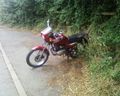
My bike parked in a layby near the farm

Me, stood roughly near where the hash point was

