Difference between revisions of "2010-07-17 36 -86"
From Geohashing
imported>Tillah! (→Achievements) |
imported>Tillah! ([live picture] Reed reherses. [http://www.openstreetmap.org/?lat=36.5687&lon=-86.5352&zoom=16&layers=B000FTF @36.5687,-86.5352]) |
||
| Line 39: | Line 39: | ||
Image:2010-07-17_36_-86_17-38-35-379.jpg | From left to right: Andrew Tiller, Reed Jones, and Taylor Jones [http://www.openstreetmap.org/?lat=36.5689&lon=-86.5352&zoom=16&layers=B000FTF @36.5689,-86.5352] | Image:2010-07-17_36_-86_17-38-35-379.jpg | From left to right: Andrew Tiller, Reed Jones, and Taylor Jones [http://www.openstreetmap.org/?lat=36.5689&lon=-86.5352&zoom=16&layers=B000FTF @36.5689,-86.5352] | ||
| + | |||
| + | Image:2010-07-17_36_-86_20-06-39-063.jpg | Reed reherses. [http://www.openstreetmap.org/?lat=36.5687&lon=-86.5352&zoom=16&layers=B000FTF @36.5687,-86.5352] | ||
</gallery> | </gallery> | ||
Revision as of 01:06, 18 July 2010
| Sat 17 Jul 2010 in 36,-86: 36.5687441, -86.5352076 geohashing.info google osm bing/os kml crox |
Location
Middle of an empty field.
Participants
Andrew Tiller, Reed Jones, Taylor Jones
Plans
"LET'S DO THIS" -Reed Jones
Expedition
Tracklog
Photos
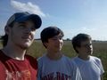
From left to right: Andrew Tiller, Reed Jones, and Taylor Jones @36.5689,-86.5352
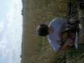
Reed reherses. @36.5687,-86.5352


Achievements
Andrew Tiller, Reed Jones, and Taylor Jones earned the Land geohash achievement
|