Difference between revisions of "2010-09-06 39 -108"
From Geohashing
imported>Messyhair42 m (→Expedition) |
imported>NWoodruff (Coordinates were not reached.) |
||
| Line 34: | Line 34: | ||
</gallery> | </gallery> | ||
| − | |||
| − | |||
| − | |||
| − | |||
| − | |||
| − | |||
| − | |||
| − | |||
| − | |||
| − | |||
| − | |||
Revision as of 12:03, 10 September 2010
| Mon 6 Sep 2010 in 39,-108: 39.0692489, -108.5129623 geohashing.info google osm bing/os kml crox |
Location
Along a ditch, approximately at the intersection of 29 and D 1/2 Rd
Participants
Plans
To stop at the hash point on the way to my work party
Expedition
My food preparation wasn't ready in time so I went to the hash point anyway and went back for food. With GPS/phone in hand i started walking the wrong direction because satellite maps were outdated and the road had recently been rerouted. I was there at precisely 4:00 and didn't meet anybody.
Photos
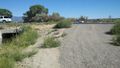
The area of the hashpoint
