Difference between revisions of "2010-12-24 43 -124"
From Geohashing
imported>Michael5000 |
imported>Michael5000 m |
||
| Line 1: | Line 1: | ||
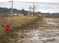
| − | + | [[File:2010-12-24 43 -124 approach.jpg|thumb|left|400px|The hashpoint is in one of the many tidal flats along the margins of Coos Bay. It would be underwater at high tide.]] | |
| − | [[File:2010-12-24 43 -124 approach.jpg|400px| | ||
{{meetup graticule | {{meetup graticule | ||
Revision as of 03:19, 28 December 2010

| Fri 24 Dec 2010 in 43,-124: 43.3753123, -124.1643310 geohashing.info google osm bing/os kml crox |
Location
In a tidal flat just off of East Bay Drive.
Participants
Expedition
Our second annual attempt to hash the Coos Bay quadrangle was a success! We had looked at the hashpoint before starting our Christmas trip, so we knew to bring heavy boots. Checking the tide table before setting out, this adventure turned out to require nothing more arduous than a half hour drive following by squelching out into thick tidal mud.
Photos
Approaching the hashpoint.
This is the place.

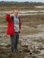
Team photo.


Achievements