Difference between revisions of "2010-12-27 40 -93"
From Geohashing
imported>Dvdllr (new exp rep) |
imported>Dvdllr |
||
| Line 1: | Line 1: | ||
| − | + | __NOTOC__ | |
| − | |||
| − | |||
| − | |||
| − | |||
| − | |||
| − | |||
| − | |||
| − | |||
| − | |||
{{meetup graticule | {{meetup graticule | ||
| lat=40 | | lat=40 | ||
| Line 15: | Line 6: | ||
}} | }} | ||
| − | |||
| − | |||
== Location == | == Location == | ||
| − | + | Southbound Interstate 35 near Lamoni, Iowa | |
== Participants == | == Participants == | ||
| − | + | *[[User:Dvdllr|Dvdllr]], Rachel, and Marvin | |
| − | |||
| − | |||
| − | |||
== Expedition == | == Expedition == | ||
| − | + | This was a sad tale! The misadventure took place during our Christmastime travels from my parents in [[Cedar Rapids, Iowa]] to my wife's parents in [[Stephenville, Texas]]. After arriving at our destination in Texas, I checked to see if we'd travelled near any geohashes in any of the eighteen different graticules we'd driven through (about a 15 hour trip, all in one day). Alas and alack, the day's hashpoint for the Princeton, Missouri graticule ended up a mere stone's throw from the interstate we'd driven on. If I'd known in advance, it would have been very easy to stop on the shoulder and at least ''try'' to get there. | |
| − | |||
| − | |||
| − | |||
== Photos == | == Photos == | ||
| − | < | + | <gallery perrow="5">. |
| − | Image:2010- | + | Image:2010-12-27 40 -93 goog_earth.PNG | Rather than post the whole tracklog, here is the important bit. |
| − | + | Image:2010-12-27 40 -93 street_view.PNG | Pshaw. | |
| − | |||
</gallery> | </gallery> | ||
== Achievements == | == Achievements == | ||
{{#vardefine:ribbonwidth|800px}} | {{#vardefine:ribbonwidth|800px}} | ||
| − | + | {{Curse of Unawareness | |
| + | | latitude = 40 | ||
| + | | longitude = -93 | ||
| + | | date = 2010-12-27 | ||
| + | | name = [[User:Dvdllr|Dvdllr]] | ||
| + | }} | ||
| − | |||
| − | |||
| − | |||
| − | |||
| − | |||
| − | |||
| − | |||
| − | |||
| − | |||
| − | |||
| − | |||
| − | |||
| − | |||
| − | |||
| − | |||
| − | |||
| − | |||
| − | |||
| − | |||
| − | |||
| − | |||
| − | |||
[[Category:Coordinates not reached]] | [[Category:Coordinates not reached]] | ||
| − | |||
| − | |||
| − | |||
| − | |||
| − | |||
| − | |||
Revision as of 03:23, 3 January 2011
| Mon 27 Dec 2010 in 40,-93: 40.6284639, -93.8863872 geohashing.info google osm bing/os kml crox |
Location
Southbound Interstate 35 near Lamoni, Iowa
Participants
- Dvdllr, Rachel, and Marvin
Expedition
This was a sad tale! The misadventure took place during our Christmastime travels from my parents in Cedar Rapids, Iowa to my wife's parents in Stephenville, Texas. After arriving at our destination in Texas, I checked to see if we'd travelled near any geohashes in any of the eighteen different graticules we'd driven through (about a 15 hour trip, all in one day). Alas and alack, the day's hashpoint for the Princeton, Missouri graticule ended up a mere stone's throw from the interstate we'd driven on. If I'd known in advance, it would have been very easy to stop on the shoulder and at least try to get there.
Photos
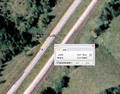
Rather than post the whole tracklog, here is the important bit.
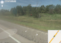
Pshaw.


Achievements
Dvdllr earned the Curse of Unawareness Consolation Prize
|