Difference between revisions of "2011-03-27 53 -1"
imported>Monty (Creation of page) |
imported>Monty (Posting.) |
||
| Line 1: | Line 1: | ||
| − | + | [[Image:{{{image|2010-03-27_53_-1_LockedGate.png}}}|thumb|left]] | |
| − | |||
| − | |||
| − | [[Image:{{{image| | ||
| − | |||
| − | |||
| − | |||
| − | |||
| − | |||
| − | |||
{{meetup graticule | {{meetup graticule | ||
| lat=53 | | lat=53 | ||
| Line 15: | Line 6: | ||
}} | }} | ||
| − | |||
__NOTOC__ | __NOTOC__ | ||
== Location == | == Location == | ||
| − | + | Farm track off of Weeton Lane, north of Harewood House, Leeds. | |
== Participants == | == Participants == | ||
| − | + | [[User:Monty|Monty]] did not ''quite'' get there. | |
== Plans == | == Plans == | ||
| − | + | With another excuse to get up into the Leeds area, an opportunity was taken to make a quick(-ish) drive up to see what the end-point today was like, before having to return to Barnsley for early afternoon. | |
| + | |||
| + | Reconnaissance via StreetView was not possible, due to the lane in question being apparently missed by the Google car when quickly checked on the Friday afternoon, so was always going to be a little ad hoc. | ||
== Expedition == | == Expedition == | ||
| − | + | Not much to tell, for the location was essentially inaccessible. The one and only useful photo of the day shows the point of nearest approach, a locked gate to a farm track and field. Even if the track would have been 'open' to the public, without a GPS at hand to allow a precise walk to the spot there would have been no value in tramping (or indeed trampling) over the crop-bearing field. | |
| + | |||
| + | The photo really has very little information to it, but in the distance (easier to see at top-resolution of photo, but not in the 640x480 version I'm uploading, sorry) you can see the farm equipment (water bowser?) visible upon the on-line aerial shots, or at least its current equivalent. | ||
| + | |||
| + | About the only other point of note, for any future expeditions in that area, is that on the way up the journey was around the Leeds Ring Road (somehow missing the A61 turn-off, and having to double back). But coming back down came straight through the middle of Leeds. Really bad traffic, even at noon on a Sunday. Won't do that again, when driving through that area. | ||
| + | |||
| + | OTOH, I now know how quickly I can get into the area and (theoretically) out of it, and Harrogate is only a dozen or so miles further north. That representing the extreme northern limit of my local geohash, it means I'm more confident that (time and transport and decent prospect of getting access permitting) I could cover hashpoints in the 53.9, and 53.0 range of latitudes. Perhaps low 54s and high 52s even. | ||
| + | |||
| + | |||
| + | On the way homeward, I note I passed over the Calder & Hebble Navigation on the M1 very close to the 2011-02-23 53 -1 hash I'd noted (in [http://wiki.xkcd.com/wgh/index.php?title=Sheffield,_United_Kingdom&oldid=271574#Planned_occasions one version] of the [[Sheffield,_United_Kingdom]] region page as a rare regional Water Hash. As well as passing within a close distance of a number of other locales of note, including some significant familial Birthday Hashpoints, albeit that they're also in various fields. | ||
== Tracklog == | == Tracklog == | ||
| − | + | Nope. (I ''really'' must get myself a GPS of some sort.) | |
== Photos == | == Photos == | ||
| − | |||
| − | |||
| − | |||
<gallery perrow="5"> | <gallery perrow="5"> | ||
| + | Image:2010-03-27_53_-1_LockedGate.png | Over there. Resisted the temptation to paint a big red arrow on the image. | ||
</gallery> | </gallery> | ||
== Achievements == | == Achievements == | ||
{{#vardefine:ribbonwidth|800px}} | {{#vardefine:ribbonwidth|800px}} | ||
| − | + | {{No trespassing | latitude = 53 | longitude = -1 | date = 2011-03-27 | name = [[User:Monty|Monty]] | image = 2010-03-27 53 -1 LockedGate.png }} | |
| − | |||
| − | |||
| − | |||
| − | |||
| − | [[ | ||
| − | |||
| − | |||
| − | |||
| − | |||
| − | |||
| − | |||
| − | |||
[[Category:Expeditions]] | [[Category:Expeditions]] | ||
| − | |||
[[Category:Expeditions with photos]] | [[Category:Expeditions with photos]] | ||
| − | |||
[[Category:Expedition without GPS]] | [[Category:Expedition without GPS]] | ||
| − | |||
| − | |||
| − | |||
| − | |||
| − | |||
| − | |||
| − | |||
[[Category:Coordinates not reached]] | [[Category:Coordinates not reached]] | ||
| − | + | [[Category:Not reached - No public access]] | |
| − | |||
| − | [[Category:Not reached - No public access]] | ||
| − | |||
| − | |||
| − | |||
Revision as of 00:56, 28 March 2011

| Sun 27 Mar 2011 in 53,-1: 53.9159722, -1.5487657 geohashing.info google osm bing/os kml crox |
Location
Farm track off of Weeton Lane, north of Harewood House, Leeds.
Participants
Monty did not quite get there.
Plans
With another excuse to get up into the Leeds area, an opportunity was taken to make a quick(-ish) drive up to see what the end-point today was like, before having to return to Barnsley for early afternoon.
Reconnaissance via StreetView was not possible, due to the lane in question being apparently missed by the Google car when quickly checked on the Friday afternoon, so was always going to be a little ad hoc.
Expedition
Not much to tell, for the location was essentially inaccessible. The one and only useful photo of the day shows the point of nearest approach, a locked gate to a farm track and field. Even if the track would have been 'open' to the public, without a GPS at hand to allow a precise walk to the spot there would have been no value in tramping (or indeed trampling) over the crop-bearing field.
The photo really has very little information to it, but in the distance (easier to see at top-resolution of photo, but not in the 640x480 version I'm uploading, sorry) you can see the farm equipment (water bowser?) visible upon the on-line aerial shots, or at least its current equivalent.
About the only other point of note, for any future expeditions in that area, is that on the way up the journey was around the Leeds Ring Road (somehow missing the A61 turn-off, and having to double back). But coming back down came straight through the middle of Leeds. Really bad traffic, even at noon on a Sunday. Won't do that again, when driving through that area.
OTOH, I now know how quickly I can get into the area and (theoretically) out of it, and Harrogate is only a dozen or so miles further north. That representing the extreme northern limit of my local geohash, it means I'm more confident that (time and transport and decent prospect of getting access permitting) I could cover hashpoints in the 53.9, and 53.0 range of latitudes. Perhaps low 54s and high 52s even.
On the way homeward, I note I passed over the Calder & Hebble Navigation on the M1 very close to the 2011-02-23 53 -1 hash I'd noted (in one version of the Sheffield,_United_Kingdom region page as a rare regional Water Hash. As well as passing within a close distance of a number of other locales of note, including some significant familial Birthday Hashpoints, albeit that they're also in various fields.
Tracklog
Nope. (I really must get myself a GPS of some sort.)
Photos
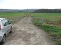
Over there. Resisted the temptation to paint a big red arrow on the image.
Achievements
Monty earned the No trespassing consolation prize
|