Difference between revisions of "2011-04-16 39 -104"
imported>AkiTensai (Created page with "<!-- If you did not specify these parameters in the template, please substitute appropriate values for IMAGE, LAT, LON, and DATE (YYYY-MM-DD format) [[Image:{{{image|IMAGE}}}|t...") |
imported>AkiTensai |
||
| Line 1: | Line 1: | ||
| − | + | [[Image:{{{image|2011-04-16_40_-104_Water_Gazebo's_Telescope_toward_Eagle_Nest.png}}}|thumb|left]] | |
| − | |||
| − | [[Image:{{{image| | ||
| − | |||
| − | |||
| − | |||
| − | |||
| − | |||
| − | |||
{{meetup graticule | {{meetup graticule | ||
| lat=39 | | lat=39 | ||
| Line 22: | Line 14: | ||
*[[user:AkiTensai|AkiTensai]] | *[[user:AkiTensai|AkiTensai]] | ||
*JediMaster | *JediMaster | ||
| − | |||
== Expedition == | == Expedition == | ||
After paying $7 to enter the park, we traveled across the opening bridge to find out we already needed to retrace our tracks. Dogs are not allowed in the south half of the park, which means poor Jedi had to be left in the truck. Though we knew we couldn't get to the hash, we still wanted to visit a gazebo nearby the hash. Along the way there, a park volunteer pointed out a eagle nest that he had a telescope to. | After paying $7 to enter the park, we traveled across the opening bridge to find out we already needed to retrace our tracks. Dogs are not allowed in the south half of the park, which means poor Jedi had to be left in the truck. Though we knew we couldn't get to the hash, we still wanted to visit a gazebo nearby the hash. Along the way there, a park volunteer pointed out a eagle nest that he had a telescope to. | ||
| Line 41: | Line 32: | ||
== Achievements == | == Achievements == | ||
{{#vardefine:ribbonwidth|800px}} | {{#vardefine:ribbonwidth|800px}} | ||
| − | + | {{No trespassing | |
| + | | latitude = 39 | ||
| + | | longitude = -104 | ||
| + | | date = 2011-04-16 | ||
| + | | name = AkiTensai and JediMaster | ||
| + | | image = 2011-04-16_40_-104_Geohash_379_ft_out.png | ||
| + | }} | ||
| + | |||
[[Category:Expeditions]] | [[Category:Expeditions]] | ||
Revision as of 08:22, 17 April 2011

| Sat 16 Apr 2011 in 39,-104: 39.9341509, -104.7544222 geohashing.info google osm bing/os kml crox |
Location
Off in the water, 400 ft off of a State Park trail. Its was located in the south half of the lake, which did not permit boat, canoe, or swimming out on the water.
Participants
- AkiTensai
- JediMaster
Expedition
After paying $7 to enter the park, we traveled across the opening bridge to find out we already needed to retrace our tracks. Dogs are not allowed in the south half of the park, which means poor Jedi had to be left in the truck. Though we knew we couldn't get to the hash, we still wanted to visit a gazebo nearby the hash. Along the way there, a park volunteer pointed out a eagle nest that he had a telescope to.
A bit further down the trail at the gazebo, we were pleasantly surprised to find a permanent fixture telescope conveniently pointed at the same nest. JediMaster tried using her camera though the telescope and learned that the digital camera could capture the image. Getting my chance at taking a picture though the scope, I learn that my simple camera's zoom works with the telescope giving a closer image. (Coders learning how light works, isn't it cute?)
The trek back was tiring for myself (Aki), having walked about three miles today. Got many cool photos, and a few pointing towards the hash.
Photos
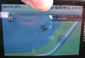
GPS, 400ft away

Towards Geohash, 379 ft away
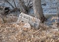
The Cake is Concrete

Water Gazebo
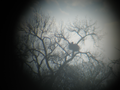
Eagle's Nest


Achievements
AkiTensai and JediMaster earned the No trespassing consolation prize
|