Difference between revisions of "2011-06-10 45 -121"
imported>Jiml m (Fix broken result code. Also, doesn't sound like a fail - You did get out and see the world!) |
imported>Jiml m (username typo) |
||
| Line 22: | Line 22: | ||
== Participants == | == Participants == | ||
| − | * [[ | + | * [[User:Kydlt|kydlt]] |
== Plans == | == Plans == | ||
Revision as of 15:01, 13 June 2011
| Fri 10 Jun 2011 in 45,-121: 45.6593365, -121.8061133 geohashing.info google osm bing/os kml crox |
Location
Today's spot is about 2 1/4 mi walk, up about 2400 ft from the end of Herman Creek Rd in Cascade Locks, OR
Participants
Plans
My topo map shows a trail most of the way there. And a road that goes up to a trailhead only about 2 1/2 miles from the hash. The cross-country leg looks to be less than 1000 ft on a traverse, so (famous last words) a pretty easy crossing. Looks to be woods.
Expedition
Thwarted.
The road to the trailhead was gated, parking there and walking in would have added another mile, I guessed. I drove around and found a different trailhead that would have taken me up trail 406 Herman Creek Trail and would have added a little more walking, but it needed a parking permit, and that was in the other car.
But I walked up the trail a little ways anyway, tempting the wilderness parking police as much as I dared, then went to Cascade Locks and walked around the park.
Photos
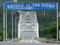
Most expeditions start at this most excellent crossing.
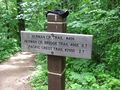
I went up far enough to know that I did find the right place.
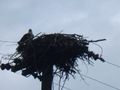
Other people were here before us. There is only so much that can be done with a pocket camera.
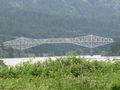
From the WA side. Technically it's a cantilever through truss.


Achievements
- No Trespassing??