Difference between revisions of "2011-07-03 39 -76"
From Geohashing
imported>1000miles1stStep |
imported>1000miles1stStep |
||
| Line 1: | Line 1: | ||
| − | |||
<!-- If you did not specify these parameters in the template, please substitute appropriate values for IMAGE, LAT, LON, and DATE (YYYY-MM-DD format) | <!-- If you did not specify these parameters in the template, please substitute appropriate values for IMAGE, LAT, LON, and DATE (YYYY-MM-DD format) | ||
| Line 11: | Line 10: | ||
--> | --> | ||
| − | [[Image: | + | [[Image:IMAGO430.JPG|thumb|left]] |
{{meetup graticule | {{meetup graticule | ||
Revision as of 21:00, 4 July 2011
| Sun 3 Jul 2011 in 39,-76: 39.1440572, -76.5689717 geohashing.info google osm bing/os kml crox |
Location
Freetown, MD
Participants
1000miles1stStep
Plans
Expedition
Route: B/W Parkway to MD Rt. 100.
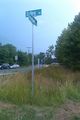
Mission accomplished at 7:08 PM. Hash point was within a few meters of the street sign for the intersection of Solley Rd. and Freetown Rd.
Weather was thunderstormy.
Tracklog
Photos
Not sure who Hanz is, and not sure I want a massage from him!


Achievements
1000miles1stStep earned the Land geohash achievement
|