Difference between revisions of "2012-01-26 57 13"
From Geohashing
imported>Cjk (→Photos) |
imported>Cjk |
||
| Line 1: | Line 1: | ||
| + | [[Image:{{{image|2012-01-26_57_13_22-37-16-195.jpg}}}|thumb|left]] | ||
| − | |||
| − | |||
| − | |||
| − | |||
| − | |||
| − | |||
| − | |||
| − | |||
| − | |||
{{meetup graticule | {{meetup graticule | ||
| lat=57 | | lat=57 | ||
| Line 19: | Line 11: | ||
== Location == | == Location == | ||
<!-- where you've surveyed the hash to be --> | <!-- where you've surveyed the hash to be --> | ||
| + | In the woods between Ullared and Värnamo, not far from a logging road. | ||
== Participants == | == Participants == | ||
<!-- who attended --> | <!-- who attended --> | ||
| + | [[User:Cjk|Carl-Johan]] | ||
== Plans == | == Plans == | ||
<!-- what were the original plans --> | <!-- what were the original plans --> | ||
| + | To deflower 2 [[Virgin Graticule|virgin graticules]] and maybe work on my minesweeper around [[Västerås, Sweden]] making this a triple hash. [https://maps.google.com/maps?saddr=R%C3%B6san,+Onsala,+Sverige&daddr=57.0735521,13.0477922+to:57.0662319,13.0887601+to:57.0763577,+13.0874229+to:57.056284,13.118041+to:57.1214,13.37995+to:57.160525,13.414299+to:57.0763577,+14.0874229+to:57.16294,14.07451+to:57.1613372,14.0773533+to:59.0763577,+16.0874229+to:59.0775361,16.0880843+to:59.34386,18.02204+to:Grevgatan,+Stockholm,+Sverige&hl=en&ie=UTF8&sll=59.328636,18.058434&sspn=0.066288,0.138359&geocode=FR_EawMdk0S3ACl_kVeG48JPRjFccDXFdAjuUQ%3BFZDfZgMd8BfHACmV9GpE5lFQRjE-1NTvvNnPfA%3BFffCZgMd-LfHACm_Mpbbm1FQRjHQ0VYIeJABEw%3BFYbqZgMdv7LHAA%3BFRycZgMdWSrIACkHL2PwZFFQRjHQ61YIeJABEw%3BFXiaZwMdbinMAClVKHlCjfdQRjF8eynGy3MXBg%3BFU0zaAMdm6_MAClPFQ4xTvZQRjGRkXQIeJABEw%3BFYbqZgMd__TWAA%3BFbw8aAMdjsLWACmR1ActLMFQRjHQTrYQeJABEw%3BFXk2aAMdqc3WAClDxLtgLcFQRjFl23agI1wTvA%3BFQZvhQMdf3n1AA%3BFaBzhQMdFHz1ACkv-D07srteRjGh9GEX8_4AEw%3BFfSDiQMdmP4SASlRP348g51fRjESIXBrWHzwFg%3BFUZjiQMdSvcTASl78vQbUJ1fRjFt09J_yehrdw&oq=R%C3%B6san+onsala&mra=dpe&mrsp=12&sz=13&via=1,2,4,5,6,8,9,11,12&t=m&z=13 This] was the route I took. | ||
| + | |||
| + | [[2012-01-26 57 13]] Virgin Graticule for [[Gislaved, Sweden]] | ||
| + | [[2012-01-26 57 14]] Virgin Graticule for [[Jönköping, Sweden]] | ||
| + | [[2012-01-26 59 16]] | ||
| + | |||
== Expedition == | == Expedition == | ||
Revision as of 23:18, 26 January 2012

| Thu 26 Jan 2012 in 57,13: 57.0763577, 13.0874229 geohashing.info google osm bing/os kml crox |
Location
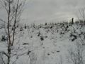
In the woods between Ullared and Värnamo, not far from a logging road.
Participants
Plans
To deflower 2 virgin graticules and maybe work on my minesweeper around Västerås, Sweden making this a triple hash. This was the route I took.
2012-01-26 57 13 Virgin Graticule for Gislaved, Sweden 2012-01-26 57 14 Virgin Graticule for Jönköping, Sweden 2012-01-26 59 16
Expedition
Tracklog
Photos
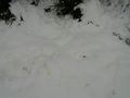
Yellow Snow. Do not eat!
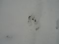
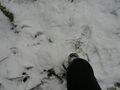
Moose tracks
Geohash in those woods
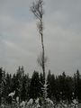
A lone birch tree

Scetchy
The way back

Stupid grin

Nomeansno, all roads leads to ausfart.
The spot
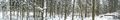
Panorama 1
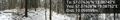
Panorama 2 with proof


Achievements